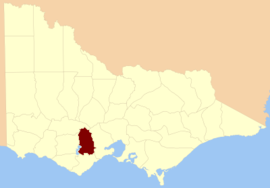
County of Grenville, Victoria
 From Wikipedia - Reading time: 4 min
| Grenville Victoria | |||||||||||||||
|---|---|---|---|---|---|---|---|---|---|---|---|---|---|---|---|
 Location in Victoria | |||||||||||||||
| |||||||||||||||
The County of Grenville is one of the 37 counties of Victoria which are part of the cadastral divisions of Australia, used for land titles. It is located to the north-east of Lake Corangamite and includes Cressy. Ballarat is on its north-eastern edge. The boundary to the east is the Yarrowee River, and to the south part of the Barwon River. Colac is on its southern edge. The county was proclaimed in 1849.
Parishes
[edit]Parishes within the county:
- Argyle, Victoria
- Ballaarat, Victoria
- Bungaree, Victoria
- Cardigan, Victoria
- Carngham, Victoria
- Clarkesdale, Victoria
- Commeralghip, Victoria
- Corindhap, Victoria
- Cressy, Victoria
- Cundare, Victoria
- Dereel, Victoria
- Doroq, Victoria
- Dreeite, Victoria
- Enfield, Victoria
- Gellibrand, Victoria
- Haddon, Victoria
- Hesse, Victoria
- Karngun, Victoria
- Kurac-a-ruc, Victoria
- Lawaluk, Victoria
- Lynchfield, Victoria
- Mannibadar, Victoria
- Mindai, Victoria
- Mirnee, Victoria
- Mortchup, Victoria
- Murdeduke, Victoria
- Naringhil North, Victoria
- Naringhil South, Victoria
- Ondit, Victoria
- Poliah North, Victoria
- Poliah South, Victoria
- Poorneet, Victoria
- Scarsdale, Victoria
- Shelford, Victoria
- Shelford West, Victoria
- Smythesdale, Victoria
- Turkeeth, Victoria
- Wallinduc, Victoria
- Warracbarunah, Victoria
- Warrambine, Victoria
- Warrion, Victoria
- Weering, Victoria
- Wilgul North, Victoria
- Wilgul South, Victoria
- Windermere, Victoria
- Wingeel, Victoria
- Wurrook, Victoria
- Yarima, Victoria
- Yarrowee, Victoria
References
[edit]37°40′S 143°40′E / 37.667°S 143.667°E
Licensed under CC BY-SA 3.0 | Source: https://en.wikipedia.org/wiki/County_of_Grenville,_Victoria13 views | Status: cached on December 31 2024 02:33:29↧ Download as ZWI file
 KSF
KSF