Dasyueshan National Forest Recreation Area
 From Wikipedia - Reading time: 5 min
| Dasyueshan National Forest Recreation Area Chinese: 大雪山國家森林遊樂區 | |
|---|---|
 | |
| Map | |
| Geography | |
| Location | Heping, Taichung, Taiwan |
| Coordinates | 24°14′41.3″N 120°58′30.0″E / 24.244806°N 120.975000°E |
| Elevation | 1,000-2,996 meters |
| Area | 3,963 hectares |
| Administration | |
| Visitation | 200,000 (annually) |
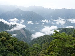
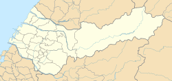
Dasyueshan National Forest Recreation Area (traditional Chinese: 大雪山國家森林遊樂區; simplified Chinese: 大雪山国家森林游乐区; pinyin: Dàxuěshān Guójiā Sēnlín Yóulè Qū) is a forest located in Heping District, Taichung, Taiwan.
Geology
[edit]The forest spans over an area of 3,963 hectares and is located at an altitude of 1,000-2,996 meters above sea level.[1] The mountains and recreational areas of the forest are located at an altitude of 2,000 meters. The mean temperature during summer is 18°C and during winter is -5°C.[2]
Tourism
[edit]The forest attracts 200,000 visitors every year.[1]
See also
[edit]References
[edit]- ^ a b "Dasyueshan Forest Recreation Area". Forestry Bureau, Council of Agriculture, Executive Yuan. 11 May 2018. Retrieved 29 August 2019.
- ^ "Aowanda National Forest Recreation Area". Dasyueshan National Forest Recreation Area. Retrieved 29 August 2019.
Wikimedia Commons has media related to Dasyueshan National Forest Recreation Area.
Licensed under CC BY-SA 3.0 | Source: https://en.wikipedia.org/wiki/Dasyueshan_National_Forest_Recreation_Area1 | Status: cached on April 26 2025 18:22:04↧ Download as ZWI file
 KSF
KSF