Diensdorf-Radlow
 From Wikipedia - Reading time: 4 min
Diensdorf-Radlow | |
|---|---|
Location of Diensdorf-Radlow within Oder-Spree district   | |
  Diensdorf-Radlow  Diensdorf-Radlow | |
| Coordinates: 52°13′59″N 14°03′00″E / 52.23306°N 14.05000°ECoordinates: 52°13′59″N 14°03′00″E / 52.23306°N 14.05000°E | |
| Country | Germany |
| State | Brandenburg |
| District | Oder-Spree |
| Municipal assoc. | Scharmützelsee |
| Subdivisions | 2 districts |
| Government | |
| • Mayor (2019–24) | Stefan Petrick[1] |
| Area | |
| • Total | 9.34 km2 (3.61 sq mi) |
| Elevation | 45 m (148 ft) |
| Population (2021-12-31)[2] | |
| • Total | 586 |
| • Density | 63/km2 (160/sq mi) |
| Time zone | UTC+01:00 (CET) |
| • Summer (DST) | UTC+02:00 (CEST) |
| Postal codes | 15864 |
| Dialling codes | 033677 |
| Vehicle registration | LOS |
| Website | www.amt-scharmuetzelsee.de |
Diensdorf-Radlow is a municipality in the Oder-Spree district, in Brandenburg, Germany.
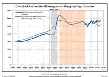
Demography[edit]
|
|
References[edit]
- ^ Landkreis Oder-Spree Wahl der Bürgermeisterin / des Bürgermeisters, accessed 2 July 2021.
- ^ "Bevölkerungsentwicklung und Flächen der kreisfreien Städte, Landkreise und Gemeinden im Land Brandenburg 2021" (PDF). Amt für Statistik Berlin-Brandenburg (in German). June 2022.
- ^ Detailed data sources are to be found in the Wikimedia Commons.Population Projection Brandenburg at Wikimedia Commons


 | This Brandenburg location article is a stub. You can help Wikipedia by expanding it. |
Licensed under CC BY-SA 3.0 | Source: https://en.wikipedia.org/wiki/Diensdorf-Radlow5 views | Status: cached on October 31 2022 09:51:38↧ Download as ZWI file
 EncycloReader
is supported by the
EncycloReader
is supported by the  KSF
KSF