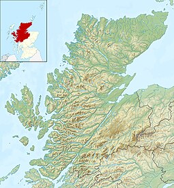
Eilean nan Ròn
 From Wikipedia - Reading time: 9 min
| Scottish Gaelic name | Eilean nan Ròn |
|---|---|
| Meaning of name | island of the seals |
| Location | |
| OS grid reference | NC637656 |
| Coordinates | 58°33′N 4°20′W / 58.55°N 4.34°W |
| Physical geography | |
| Island group | Highland / Islands of Sutherland |
| Area | 138 hectares (9⁄16 sq mi) |
| Area rank | 129= [1] |
| Highest elevation | Cnoc an Loisgein, 76 m (249 ft) |
| Administration | |
| Council area | Highland Council |
| Country | Scotland |
| Sovereign state | United Kingdom |
| Demographics | |
| Population | 0 |
| References | [2][3] |
Eilean nan Ròn (Scottish Gaelic: island of the seals) is an island near Skerray, in the north of Sutherland, Scotland.[4] An estimated 350 seal pups are born here annually.

History
[edit]Eilean nan Ròn was populated for many years. 73 people lived there in 1881 and 30 in 1931 but it has been uninhabited since 1938.[5] The final evacuation list contained nine people from the Mackay family – Christina Bella Mackay, Hector Sinclair Mackay, Jessie Ann Mackay, Willie John Mackay, Hugh Campbell Mackay, Donald Mackay, Ina Mackay, Chrissie Dolina Mackay and Christina Mackay.
The ruins of a settlement can be seen from the Skerray and in the waist of the island, between Mol na Coinnle ("Pebble Beach of the Candles") and Mol Mòr ("big pebble beach").[3]
Geography and geology
[edit]Eilean nan Ròn is not one of the Hebrides, which lie off the west coast of mainland Scotland. The island is mainly sandstone with steep cliffs on the north and east coasts and a natural arch at Leathad Ballach.,[3] which is 150 ft (46 m) high, and 70 ft (21 m) wide.[4] The high points are Cnoc an Loisgein at 76 m (249 ft), and Cnoc na Caillich at 75 m (246 ft). As Rev. Wilson wrote in 1882:
- It looks like two islands, is mostly engirt with high precipitous rocks, includes a low tract of very fertile soil.[4]
There are several islets and islands off Eilean nan Ròn. These include the tidal Eilean Iosal (low island), and beyond it Meall Thailm (or "Meall Holm"). To the south west is the dully named An Innis ("small island"). The Rabbit Islands are in Tongue Bay to the south west.
Wildlife
[edit]As the name implies, Eilean nan Ròn is popular with grey seals, that come here in their hundreds each autumn to pup.[6] About 350 calves are born each year.[3] The island also has large numbers of seabirds, and sheep, which were left when the Island was evacuated.
Media Coverage
[edit]The island was subject of a BBC news report[7] in 2024, when a BBC reporter traced his family history to the island and subsequently visited it.
See also
[edit]Footnotes
[edit]- ^ Area and population ranks: there are c. 300 islands over 20 ha in extent and 93 permanently inhabited islands were listed in the 2011 census.
- ^ National Records of Scotland (15 August 2013). "Appendix 2: Population and households on Scotland's Inhabited Islands" (PDF). Statistical Bulletin: 2011 Census: First Results on Population and Household Estimates for Scotland Release 1C (Part Two) (PDF) (Report). SG/2013/126. Retrieved 14 August 2020.
- ^ a b c d Smith (2004) pp. 201-03
- ^ a b c Wilson, Rev. John The Gazetteer of Scotland (Edinburgh, 1882) Published by W. & A.K. Johnstone
- ^ "Kitty Ann NicCuithein, Eilean nan Ròn, 1918-2019". 20 February 2019. Retrieved 26 February 2019.
- ^ "Talmine". Undiscovered Scotland. Retrieved 14 December 2007.
- ^ "Family history hunt ends on tiny island home to just seals and sheep". BBC News. 5 January 2024. Retrieved 6 January 2024.
References
[edit]- Haswell-Smith, Hamish (2004). The Scottish Islands. Edinburgh: Canongate. ISBN 978-1-84195-454-7.
 KSF
KSF
