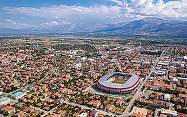
Erzincan Province
 From Wikipedia - Reading time: 8 min
Erzincan Province
Erzincan ili | |
|---|---|
 | |
 Location of the province within Turkey | |
| Country | Turkey |
| Seat | Erzincan |
| Government | |
| • Governor | Hamza Aydoğdu |
Area | 11,815 km2 (4,562 sq mi) |
| Population (2022)[1] | 239,223 |
| • Density | 20/km2 (52/sq mi) |
| Time zone | UTC+3 (TRT) |
| Area code | 0446 |
| Website | www |
Erzincan Province (Turkish: Erzincan ili; Kurdish: Parezgêha Erzînganê;[2] Armenian: Էրզինկանի զավառ) is a province in the Eastern Anatolia Region of Turkey. In Turkey, its capital is also called Erzincan. Its area is 11,815 km2,[3] and its population is 239,223 (2022).[1]


Geography
[edit]Erzincan is traversed by the northeasterly line of equal latitude and longitude. It lies on the Northern Anatolian Fault, where it is often the location for earthquakes such as on 27 December 1939[4] and 13 March 1992.[5]
History
[edit]In September 1935 the third Inspectorate General (Umumi Müfettişlik, UM) was created,[6] into which the Erzincan province was included. Its creation was based on the Law 1164 from June 1927,[6] which was passed in order to Turkefy the population.[7] The Erzincan province was included in this area. The third UM span over the provinces of Erzurum, Artvin, Rize, Trabzon, Kars, Gümüşhane, Erzincan and Ağrı. It was governed by an Inspector General seated in the city of Erzurum.[6][8] In January 1936, a Fourth Inspectorate-General was established,[9] under which authority the province was transferred. The fourth UM included the provinces of Erzincan, Tunceli, Elazığ and the areas which would become the province of Bingöl.[8] The Fourth UM was governed by a Governor Commander. Most of the employees in the municipalities were to be from the military and the Governor Commander had the authority to evacuate whole villages and resettle them in other areas.[8] The Inspectorates General were dissolved in 1952 during the Government of the Democrat Party.[10]
Districts
[edit]
Erzincan province is divided into 9 districts (capital district in bold):
See also
[edit]- 1939 Erzincan earthquake
- List of populated places in Erzincan Province
- Battle of Otlukbeli Martyrs' Monument
References
[edit]- ^ a b "Address-based population registration system (ADNKS) results dated 31 December 2022, Favorite Reports" (XLS). TÜİK. Retrieved 19 September 2023.
- ^ "Li Wan û Erzînganê ji ber berfê rêyên 144 tax û gundan hatin girtin" (in Kurdish). Rûdaw. 3 December 2019. Retrieved 27 April 2020.
- ^ "İl ve İlçe Yüz ölçümleri". General Directorate of Mapping. Retrieved 19 September 2023.
- ^ Rosie Ayliffe, Marc Dubin, John Gawthrop, Terry Richardson, Turkey, 1136 pp., Rough Guides, 2003, ISBN 1-84353-071-6, ISBN 978-1-84353-071-8 (see p.1016)
- ^ Grosser, H.; Baumbach, M.; Berckhemer, H.; Baier, B.; Karahan, A.; Schelle, H.; Krüger, F.; Paulat, A.; Michel, G.; Demirtas, R.; Gencoglu, S. (1998-10-01). "The Erzincan (Turkey) Earthquake of 13 March 1992 and its Aftershock Sequence". Pure and Applied Geophysics. 152 (3): 465–505. doi:10.1007/s000240050163. ISSN 0033-4553. S2CID 129640525.
- ^ a b c "Üçüncü Umumi Müfettişliği'nin Kurulması ve III. Umumî Müfettiş Tahsin Uzer'in Bazı Önemli Faaliyetleri". Dergipark. p. 2. Retrieved 8 April 2020.
- ^ Üngör, Umut. "Young Turk social engineering : mass violence and the nation state in eastern Turkey, 1913- 1950" (PDF). University of Amsterdam. pp. 244–247. Retrieved 8 April 2020.
- ^ a b c Bayir, Derya (2016-04-22). Minorities and Nationalism in Turkish Law. Routledge. pp. 139–141. ISBN 978-1-317-09579-8.
- ^ Cagaptay, Soner (2 May 2006). Islam, Secularism and Nationalism in Modern Turkey: Who is a Turk?. Routledge. pp. 108–110. ISBN 978-1-134-17448-5.
- ^ Fleet, Kate; Kunt, I. Metin; Kasaba, Reşat; Faroqhi, Suraiya (2008-04-17). The Cambridge History of Turkey. Cambridge University Press. p. 343. ISBN 978-0-521-62096-3.
External links
[edit]- (in Turkish) Erzincan governor's official website
- (in Turkish) Erzincan municipality's official website
- (in English) Erzincan weather forecast information
39°40′42″N 39°19′48″E / 39.67833°N 39.33000°E
 KSF
KSF
