Fürberg (Bavarian Forest)
 From Wikipedia - Reading time: 3 min
| Fürberg | |
|---|---|
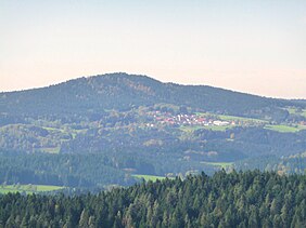
 The Fürberg and the village of Untermitterdorf seen from the Oberkreuzberg viewing tower | |
| Highest point | |
| Elevation | 880 m (2,890 ft) |
| Coordinates | 48°52′14″N 13°12′45″E / 48.8706°N 13.2125°E |
| Geography | |
| Parent range | Bavarian Forest |
| Geology | |
| Rock type | granite |
The 880-metre-high Fürberg is one of the smaller mountains in the Danube Hills, the lower part of the Bavarian Forest. It rises in the municipality of Kirchberg im Wald.
At the summit is the Plattenstein, an interesting rock formation with a summit cross and view southwards to the higher Brotjacklriegel. A little further below is the Fürberg Chapel, which can be reached by walking along a way of the cross from Untermitterdorf. The Fürberg can be climbed on various footpaths in a short time from the small villages of Raindorf, Untermitterdorf or Berneck.
Licensed under CC BY-SA 3.0 | Source: https://en.wikipedia.org/wiki/Fürberg_(Bavarian_Forest)6 views | Status: cached on November 24 2024 18:51:49↧ Download as ZWI file
 KSF
KSF