Furg Citadel
 From Wikipedia - Reading time: 15 min
 Forg Castle (Mirza Rafi Khan Castle) | |
| Location | Darmian, Iran |
|---|---|
| Region | South Khorasan Province |
| Coordinates | 32°50′41″N 59°56′55″E / 32.8448°N 59.9485°E |
| Type | Settlement |
| History | |
| Periods | Afsharian |
| Site notes | |
| Ownership | Mixed public and private |
| Public access | Partial |


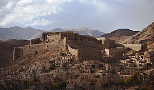
Furg Citadel (Arg e Furg, also known as Forg citadel and Mirza Rafi Khan citadel) is an 18th-century citadel located in Furg Village in Darmian County, South Khorasan, Iran.
Furg Citadel was constructed by Meerza Muhammad Rafiee Darmiany I (Lama).[1] It was registered in the List of National Works on March 18, 2001.
Name
[edit]There are different origin stories for the name of Forg/Furg. One of the more common is that Forg was commonly pronounced "Fork" among the people. The Dehkhoda Dictionary, in a quote from the Encyclopedia, explicitly mentions that "Fork" was the name of the ancestor of a family in Iran, and is an Iranian name.
Other versions suggest that Fork was the name of the daughter of "Ryan Konouj", an Indian king; that Fork was the wife of Bahram Gour (as stated in Borhan); and/or that perhaps the name stems from the Persian word pour, meaning "son". Still other theories attribute Fork to the founder of this village, i.e. Mozafar Keyghobad, and based on an inscription on which the year of 307 is written, they infer that as the founder of this village was initially "Pour Keyghobad", it was first called "Pourg", and then renamed to Fork and then to Forg over time.[2]
Location
[edit]Furg Citadel is located on the north side of Fork Village at an altitude of 1840 meters. It is on the edge of the heights of Darmian Valley, leading to the Asadiyeh plain. Furg Citadel covers about 9,200 square meters, extending from east to west.
Description
[edit]The citadel today has three major sections
Section 1
[edit]Section 1 of the citadel contains a barn on the east side that served as living quarters for the staff, as a cattle barn and as a dock warehouse.
This section also includes a citadel entrance, guard towers, water storage and other spaces.
Section 2
[edit]Section 2 is a tall central area that is 50 meters from the storage areas, armory and barracks. The citadel has a brick tower with cruciform or lozenge design decorations in the northeast corner.
Section 3
[edit]Section 3 encompasses two floors overlooking the village and roads of the area. It is located in the west and is separated from section 2 by two towers and fortified and long walls. Most of the second floor has been destroyed.
Tunnel
[edit]The tunnel has approximately 100 usable stairs.
The current tunnel was allegedly used during the battle between Mirza Rafi Khan with Mir Alam Khan and his son Amir Asadollah Khan. This battle is referred to in Einolvaghaye[3]
"… Esmaeil Khan, Atakhan, and their families obeyed and followed; and Afghans with Mirza Rafi Khan, Haji Fathkhan Afghan and Behboud son of Nazarkhan Ghalehgahi erected a burrow on one side of the citadel and escaped at night".
However, given the length of time needed to bore a tunnel, the author might be referring to an earlier structure.
History
[edit]Construction
[edit]Based on the existing documents, the Book of Divan-e-Lame [4] and local comments, construction of the Furg Citadel began in early 1160 AH, during the reign of Nader Shah Afshar, by Mirza Bagha Khan, son of the First Mirza Rafi Khan. The citadel was completed by his son, the Second Mirza Rafi Khan.
However, the Divan-e-Lame also says:
"But, was it really started the building of the citadel by Mirza Bagha Khan and completed by his son, Mirza Rafi Khan (Lame's grandson) or is it one of the old buildings and these two persons and the former ones, everyone has had a hand in it and made effort to repair and complete it, is something that has not been achieved yet; not based on the written documents and not through oral promise of the elders.
It is likely that Lame and his father had possessed the citadel and it was their place of residence and administration center and shelter [5] The Book of Haghayeghol Akhbr Naseri,[6] discusses the events of the lunar year of 1268 about Mirza Rafi Khan:
"In the same year, Mirza Rafi Khan, who was staying in Ghaenat places, started to oppose, General Pashakhan with two legions from city of Semnan and a collective of cavalry and forty cannons were also assigned to punish him. Mirza Rafi Khan went to Harat. Zahiroddoleh interceded for him, and his crime was pardoned."
Qajar era
[edit]An inscription carved on the mortar surface of the water storage of the citadel indicates the lunar date of 1217.
Riazi Heravi writes in Einolvaghayeh Book as follows:
"Forg citadel is 12 miles away from Birjand and locates around plain and entrance of "Darmian" valley and has a lot of gardens and trees and enjoys a good climate, the citadel is on the top of a mountain of which walls and towers have been firmly constructed by mud bricks and its foundation was made by Ajin stone and has two Haji Shir around itself and two embankments each of which diameter is five cubits.
European visitors
[edit]Furg Citadel was described by a "Doctor Forbes" [7] in 1814 AD, a "Colonel MacGerger" [8] in 1875, and a "Khanykf" and "Blue". MacGerger cited Forbes in his itinerary titled "A Journey to the Province of Khorasan" as follows:
"The citadel has been built on the top of a hill at an altitude of 2000 to 2500 feet which could be threatened by the fire load from the highlands of the north and west. A mountain is located in the south and on the other two sides which is away 1200 yards from the peak to the walls of the citadel. Three water storages were provided inside the citadel which is said that the storage of their water will supply the utility of a great garrison for the period of one year and six months.[9]

Archaeological excavation
[edit]In 2001, an excavation was conducted at Furg Citadel. It identified a stable, food storage areas, burrows and corridors connecting different sections of the citadel.[10]
Evidence shows that the citadel was actually built in the Afsharieh era. The classification of Furg citadel as an Ismailia structure [11] is debatable. Ismailia citadels [12] were constructed in remote and hidden from view.
Like other official citadels in Iran, the Furg consisted of three sections:
- Kohandej (place of living the ruler),
- Sharestan (Place of living of the people of village)
- Rabath (farms and gardens) sections
See also
[edit]References
[edit]- ^ Divan, Lama (1365). Divan Lama. Sanobar.
- ^ City of "Darmian" has been located inside the mountains known as "Momenabad" in the east region of Iran which has been considered as a part of "Ghohestan" or "Kouhestan" vast territory in the past historical division. Momenabad district has very likely taken its name from Momenabad Mountain. Momenabad Mountain locating in South Khorasan with the altitude of 9100 feet is the highest mountain. In the Book of the Region History which is a compilation of Shah Abbas Safavid era, the political divisions of Ghohestan have been mentioned as follows: Ghohestan is a province with enough people in which there are many ranked and intellectual persons who was born there.
- ^ Einolvaghaye is a book categorized as the general historiography including incidents of the history of Afghanistan from the year of 1207 through 1324 AH, authored by Mohammad Yousef Riazi Heravi. This book was written by Mohammad Yousef Riazi Heravi in City of Mashhadolrezaye Razavi in 1324 AH, 1906 A.D., in the period of immigration and being away from homeland. The edition of this book was terminated on February 19, 1990 in city of Mashhadolreza by Mohammad Asef Fekrat, and for the first time was published with circulation of two thousand copies in 1990. The "publisher" of this book is Dr. Mahmoud Afshar Yazdi Endowment Foundation and the book has been printed at the printing house of the University of Tehran. This book is a collection of historical instruments and documents of Naseri and Mozafari Eras.
- ^ Divane Lame, Mohammad Rafi Ebne Abolkarim Darmiani, edited by Dr. Mahmoud Rafi and Dr. Mazaher Mosafa, published by Dr. Mahmoud Rafi, Tehran.
- ^ The same as mentioned in Page No. 89
- ^ Haghayegholakhbare Naseri is a Persian-language book of chronicles from the Qajar Era authored by Mohammad Jafar Ebne Mohammadali Khormoji, edited by Hossein Khadiv Jam, an author of Mohammad Jafar Khormoji, a historian of Nasereddin Shah Qajar's royal, known as Haghayeghnegar (Fact Journalist). He commenced writing this book at the request of Nasereddin Shah in 1276AH and as he himself says in its introduction, he was requested not to say anything in his history other than the truth and fair one and not to consider traitor as servant and escaper as attacker. Khormoji completed writing of the first volume in Jamadiol Avval (the fifth month of the Arabic lunar year) 1279AH, and then started writing the second volume. The book was written in two volumes. The first volume includes a preface written by the editor, Mr. Hossein Khadiv Jam; a note about the author written by Iraj Afshar; the subject-matter of the book and description of events until 1279AH. The second volume consists of the author's introduction and mentioning the events of the years of 1278 and 1279AH.
- ^ Forbes, Frederick, Rawlinson W. Route from Turbat Haidari, in Khorasan, to the River Harir Rud, on the Borders of Sistan. Journal of the Royal Geographical Society of London, Vol. 14. (1844)
- ^ Mac. Gerger, Colonel C. M., Description of a journey to the Province of Khorasan, translated by Majid Mehdizadeh, Mashhad, Deputy Office for Cultural Affairs, Astan Ghods Razavi, 1987.
- ^ Mofid Shateri, Mehdi Rafiei, Behnaz Nejati, Darmian Nameh with Pointing out to Forg, Birjand, Chahar Derakht, 2015, Page, 175
- ^ Nasrabadi, Alireza, Forg Castle Registration Report, Archive of the Deputy Office for Deputy Office for Cultural Heritage, Handicrafts and Tourism of South Khorasan, 2001.
- ^ Ismailian State was a government founded in the City of Qazvin by conquering Alamout Castle in the year of 483 AH, and their commanding period continued until 654AH. The commanding center of Ismailian was Alamout Castle, and their main activity was fighting against the Abbasides Caliphs and Mongol tribes. Hassan Sabbah, as the most prominent commander of Ismailian, was able to expand his scope of power to the present Syria by extensive advertising amongst farmers and the poor. Finally, the Islamilian Government, after having ruled over Qazvin for the period of 200 years, was destroyed as a result of the Mongol Holakokhan’s assail.
- ^ Ismailian Castles in Alborz Mountain Chain, written by Manouchehr Sotoudeh, Tehran, Tahori Publication, 1983
 KSF
KSF


