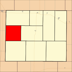
Gaeland Township, Gove County, Kansas
 From Wikipedia - Reading time: 4 min
Gaeland Township | |
|---|---|
 Location in Gove County | |
| Coordinates: 38°56′21″N 100°43′55″W / 38.93917°N 100.73194°W | |
| Country | United States |
| State | Kansas |
| County | Gove |
| Area | |
• Total | 80.37 sq mi (208.15 km2) |
| • Land | 80.37 sq mi (208.15 km2) |
| • Water | 0 sq mi (0 km2) 0% |
| Elevation | 2,943 ft (897 m) |
| Population (2000) | |
• Total | 46 |
| • Density | 0.6/sq mi (0.2/km2) |
| GNIS feature ID | 0471376 |
Gaeland Township is a township in Gove County, Kansas, USA. As of the 2000 census, its population was 46.
Geography
[edit]Gaeland Township covers an area of 80.37 square miles (208.2 km2) and contains no incorporated settlements.
Transportation
[edit]Gaeland Township contains two airports or landing strips: Evans Airport and Stevenson Airport.
References
[edit]External links
[edit]
Licensed under CC BY-SA 3.0 | Source: https://en.wikipedia.org/wiki/Gaeland_Township,_Gove_County,_Kansas7 views | Status: cached on November 30 2024 02:15:55↧ Download as ZWI file
 KSF
KSF