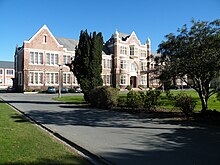
Gladstone, Invercargill
 From Wikipedia - Reading time: 8 min
Gladstone | |
|---|---|
 | |
| Coordinates: 46°23′38″S 168°20′49″E / 46.394°S 168.347°E | |
| Country | New Zealand |
| City | Invercargill |
| Local authority | Invercargill City Council |
| Area | |
| • Land | 127 ha (314 acres) |
| Population (June 2024)[2] | |
• Total | 2,520 |
| Grasmere | Prestonville | |
|
|
Rosedale | |
| Invercargill Central | Avenal | Windsor |
Gladstone is a suburb of New Zealand's southernmost city, Invercargill.
The area is low-lying and at risk from flooding and sea level rise.[3]
History
[edit]The suburb was targeted during a six week burglary spree in December 2019 and January 2020.[4]
In July 2020, a member of the public was injured during the aggravated robbery of a Gladstone convenience store.[5] Two men were charged over the incident the following month.[6]
In September 2020, the Southland Times reported high demand for land and housing in Gladstone.[7] However, in November 2020, Quotable Values released statistics showing house values were increasing at a slower rate than the rest of Invercargill.[8]
Demographics
[edit]Gladstone covers 1.27 km2 (0.49 sq mi)[1] and had an estimated population of 2,520 as of June 2024,[2] with a population density of 1,984 people per km2.
| Year | Pop. | ±% p.a. |
|---|---|---|
| 2006 | 2,484 | — |
| 2013 | 2,385 | −0.58% |
| 2018 | 2,376 | −0.08% |
| Source: [9] | ||
Gladstone had a population of 2,376 at the 2018 New Zealand census, a decrease of 9 people (−0.4%) since the 2013 census, and a decrease of 108 people (−4.3%) since the 2006 census. There were 942 households, comprising 1,152 males and 1,224 females, giving a sex ratio of 0.94 males per female. The median age was 44.4 years (compared with 37.4 years nationally), with 420 people (17.7%) aged under 15 years, 414 (17.4%) aged 15 to 29, 1,200 (50.5%) aged 30 to 64, and 339 (14.3%) aged 65 or older.
Ethnicities were 89.0% European/Pākehā, 9.8% Māori, 1.8% Pasifika, 6.1% Asian, and 2.0% other ethnicities. People may identify with more than one ethnicity.
The percentage of people born overseas was 15.3, compared with 27.1% nationally.
Although some people chose not to answer the census's question about religious affiliation, 46.3% had no religion, 44.2% were Christian, 0.1% had Māori religious beliefs, 0.5% were Hindu, 0.3% were Muslim, 0.9% were Buddhist and 1.1% had other religions.
Of those at least 15 years old, 543 (27.8%) people had a bachelor's or higher degree, and 291 (14.9%) people had no formal qualifications. The median income was $39,900, compared with $31,800 nationally. 483 people (24.7%) earned over $70,000 compared to 17.2% nationally. The employment status of those at least 15 was that 1,080 (55.2%) people were employed full-time, 357 (18.3%) were part-time, and 54 (2.8%) were unemployed.[9]

Education
[edit]Southland Boys' High School is a single-sex state secondary school for years 7 to 13[10] with a roll of 1010 students as of August 2024.[11] The school first opened in 1881 and moved to its current site in 1926.[12]
Waihopai School is a state primary school for years 1 to 6[13] with a roll of 334 students. The school opened in 1914 as Queen's Park School and adopted its current name one year later. It was formed by the merger of Invercargill Park School and Gladstone (Waihopai) School.[14]
References
[edit]- ^ a b "ArcGIS Web Application". statsnz.maps.arcgis.com. Retrieved 10 February 2022.
- ^ a b "Aotearoa Data Explorer". Statistics New Zealand. Retrieved 26 October 2024.
- ^ Mack, Ben (10 November 2015). "Rising seas threaten Southland, experts say". stuff.co.nz. Southland Times.
- ^ Kidd, Rob (23 July 2020). "DNA traces lead to burglar's capture". Allied Press. Otago Daily Times.
- ^ Harding, Evan (31 July 2020). "Distressed store worker comforted by father after robbery: witness". stuff.co.nz. Southland Times.
- ^ Harding, Evan (14 August 2020). "Second man faces charges relating to Invercargill dairy robbery". stuff.co.nz. Southland Times.
- ^ Harding, Evan (27 September 2020). "Post-Covid sales boost for Invercargill subdivisions". stuff.co.nz. Southland Times.
- ^ Pasco, Karen (13 November 2020). "Valuation increases significant". Allied Press. Otago Daily Times.
- ^ a b "Statistical area 1 dataset for 2018 Census". Statistics New Zealand. March 2020. Gladstone (Invercargill City) (361100). 2018 Census place summary: Gladstone (Invercargill City)
- ^ Education Counts: Southland Boys' High School
- ^ "New Zealand Schools Directory". New Zealand Ministry of Education. Retrieved 17 September 2024.
- ^ "History and Tradition". Southland Boys' High School. Retrieved 10 February 2022.
- ^ Education Counts: Waihopai School
- ^ "Waihopai School". Invercargill Archives. Retrieved 10 February 2022.
 KSF
KSF