Grand Canal (Phoenix)
 From Wikipedia - Reading time: 5 min
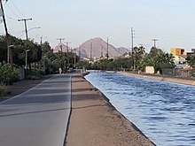
 Grand Canal at 3rd Avenue facing east | |
 | |
| Location | Phoenix, Arizona |
|---|---|
| Country | United States |
| Specifications | |
| Length | 23.5 miles (37.8 km) |
| Maximum height above sea level | 1,160 ft (350 m) |
| Navigation authority | Not navigable |
| History | |
| Original owner | Grand Canal Company |
| Geography | |
| Direction | Westward |
| Start point | Washington Street and North Center Parkway |
| End point | West Bethany Home Road and North 107th Ave. |
| Beginning coordinates | 33°26′21″N 111°56′47″W / 33.4391°N 111.9463°W |
| Ending coordinates | 33°31′22″N 112°17′27″W / 33.5227°N 112.2909°W |
The Grand Canal is a major canal in central Maricopa County, Arizona in the United States, that aided in the early agricultural development of Phoenix, now running through many of the historic neighborhoods in central Phoenix.[1] The canal now serves to feed municipal water systems in the Valley of the Sun as well as neighborhoods that practice flood irrigation for landscaping.[2]
History
[edit]The Grand Canal is the oldest remaining pioneer canal on the north side of the Salt River. The canal was once lined with towering cottonwood trees and was a popular recreation spot for Phoenicians.[3] It was planned in 1877 and constructed in 1878 by the Grand Canal Company.[4]
The federal government purchased the Grand Canal for $20,488 in June 1906, as part of the Newlands Reclamation Act,[5] and it became part of the newly created Salt River Project.[6]
Grand Canalscape
[edit]The Grand Canalscape is[when?] a 22.5 million dollar effort to revitalize the banks of the Grand Canal and encourage investment in the surrounding neighborhoods.[7] The project includes a paved multi-use path, art installations and improved signal crossings at major streets.[8]
References
[edit]- ^ "History of Phoenix's Grand Canal". cronkiteworks.asu.edu. Archived from the original on 2018-08-16. Retrieved 2019-10-21.
- ^ "How irrigation works | SRP". www.srpnet.com. Retrieved 2019-10-21.
- ^ Gardiner, Dustin. "Lifeblood of Phoenix: 7 things to know about canals". azcentral. Retrieved 2019-10-21.
- ^ "Development of the Salt River Valley". www.usbr.gov. Retrieved 2019-10-21.
- ^ "Canal origins". www.srpnet.com. Retrieved 2019-10-21.
- ^ "SRP: Canal history". www.srpnet.com. Retrieved 2019-10-21.
- ^ Gardiner, Dustin. "Lifeblood of Phoenix: 7 things to know about canals". azcentral. Retrieved 2019-10-21.
- ^ "Street Transportation Grand Canalscape Phase I". www.phoenix.gov. Retrieved 2019-10-21.
 KSF
KSF