Hartha
 From Wikipedia - Reading time: 6 min
Hartha | |
|---|---|
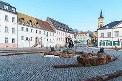
 Main square of Hartha | |
Location of Hartha within Mittelsachsen district  | |
| Coordinates: 51°5.868′N 12°58.638′E / 51.097800°N 12.977300°E | |
| Country | Germany |
| State | Saxony |
| District | Mittelsachsen |
| Government | |
| • Mayor (2022–29) | Ronald Kunze[1] |
| Area | |
• Total | 54.29 km2 (20.96 sq mi) |
| Elevation | 326 m (1,070 ft) |
| Population (2022-12-31)[2] | |
• Total | 6,777 |
| • Density | 120/km2 (320/sq mi) |
| Time zone | UTC+01:00 (CET) |
| • Summer (DST) | UTC+02:00 (CEST) |
| Postal codes | 04746 |
| Dialling codes | 034328 |
| Vehicle registration | FG |
| Website | www.hartha.de |
Hartha is a town in the district of Mittelsachsen, in Saxony, Germany. It is situated 11 km west of Döbeln, and 12 km north of Mittweida.
Personalities
[edit]- Carl Grünberg (1847–1906), woven goods manufacturer in Hartha and politician (SPD), MdR, MdL (Kingdom of Saxony)
- Hans Jahn (1885–1960), politician of the Social Democratic Party of Germany, trade unionist and resistance fighter against the National Socialism
- Richard Müller (chemist) (1903–1999), chemist, discoverer of the silicone, Müller-Rochow synthesis
References
[edit]- ^ Gewählte Bürgermeisterinnen und Bürgermeister im Freistaat Sachsen, Stand: 17. Juli 2022, Statistisches Landesamt des Freistaates Sachsen.
- ^ "Einwohnerzahlen nach Gemeinden als Excel-Arbeitsmappe" (XLS) (in German). Statistisches Landesamt des Freistaates Sachsen. 2024.
Licensed under CC BY-SA 3.0 | Source: https://en.wikipedia.org/wiki/Hartha10 views | Status: cached on June 11 2025 05:13:39↧ Download as ZWI file
 KSF
KSF

