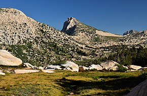
Hawksbeak Peak
 From Wikipedia - Reading time: 6 min
| Hawksbeak Peak | |
|---|---|
 South aspect (left), from Thompson Canyon | |
| Highest point | |
| Elevation | 11,134 ft (3,394 m)[1][2] |
| Prominence | 874 ft (266 m)[1] |
| Parent peak | Center Mountain (11,271 ft)[3] |
| Isolation | 1.13 mi (1.82 km)[3] |
| Listing | Vagmarken Club Sierra Crest List[4] |
| Coordinates | 38°09′09″N 119°30′29″W / 38.1525394°N 119.5080866°W[5] |
| Geography | |
| Location | Yosemite National Park Mono / Tuolumne counties California, U.S. |
| Parent range | Sierra Nevada |
| Topo map | USGS Tower Peak |
| Geology | |
| Rock age | Cretaceous |
| Mountain type | Fault block |
| Rock type | Granodiorite |
| Climbing | |
| Easiest route | class 1 South slope[6] |
Hawksbeak Peak is a mountain summit with an elevation of 11,134 feet (3,394 m) located on the crest of the Sierra Nevada mountain range, in northern California, United States. The granitic summit is situated on the common boundary shared by Yosemite National Park with Hoover Wilderness, as well as the common border of Mono County and Tuolumne County. This remote peak is set at the head of Thompson Canyon, approximately eight miles west of Twin Lakes and 17 miles southwest of Bridgeport, the nearest town. Topographic relief is significant as the west aspect rises over 1,300 feet (400 meters) in less than one-quarter mile. The class 5.10- West Face was first climbed in September 1989 by Alan Swanson and John Nye.[6] This landform's toponym has been officially adopted by the U.S. Board on Geographic Names.[7]
Climate
[edit]According to the Köppen climate classification system, Hawksbeak Peak is located in an alpine climate zone.[8] Most weather fronts originate in the Pacific Ocean and travel east toward the Sierra Nevada mountains. As fronts approach, they are forced upward by the peaks (orographic lift), causing moisture in the form of rain or snowfall to drop onto the range. Precipitation runoff from this landform drains northwest into headwaters of the West Walker River, and south to Rancheria Creek via Thompson Canyon.

See also
[edit]References
[edit]- ^ a b "Hawksbeak Peak, California". Peakbagger.com. Retrieved 2022-06-21.
- ^ USGS Topographic map Tower Peak
- ^ a b "Hawksbeak Peak - 11,134' CA". listsofjohn.com. Retrieved 2022-06-21.
- ^ "Vagmarken Sierra Crest List". Angeles Chapter, Sierra Club. Retrieved 2022-06-21.
- ^ "Hawksbeak Peak". Geographic Names Information System. United States Geological Survey, United States Department of the Interior. Retrieved 2022-06-21.
- ^ a b R. J. Secor, The High Sierra Peaks, Passes, Trails, 1992, Mountaineers Books, ISBN 9780898863130, p. 476.
- ^ Decisions on Geographic Names in the United States, United States Board on Geographic Names, 1991, p. 5
- ^ "Climate of the Sierra Nevada". Encyclopædia Britannica.
External links
[edit]- Weather forecast: Hawksbeak Peak
- Hawksbeak Peak's West Face (photo): Flickr
- North Face above Kirkwood Lake: Flickr photo
 KSF
KSF
