Hemispheres of Earth
 From Wikipedia - Reading time: 6 min


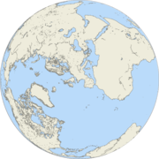
In geography and cartography, hemispheres of Earth are any division of the globe into two equal halves (hemispheres), typically divided into northern and southern halves by the Equator and into western and eastern halves by the Prime meridian. Hemispheres can be divided geographically or culturally, or based on religion or prominent geographic features. Use of these divisions is applied when studying Earth's geographic distribution, cultural differences, and other geographic, demographic and socioeconomic features.[1]
Geographical hemispheres
[edit]Geographical hemispheres are primarily split by latitudinal (north-south) and longitudinal (east-west) markers: [2][3]
North-South
- Northern Hemisphere: The half that lies north of the Equator. This hemisphere contains approximately 68% of Earth's landmass and is home to about 90% of the global population.[4] It includes North America, Europe, Asia, and most of Africa.
- Southern Hemisphere: The half that lies south of the Equator. It contains approximately 32% of Earth's landmass and is home to about 10% of the global population. It includes South America, Australia, Antarctica, and the southern parts of Africa.
East-West
- Eastern Hemisphere: The half that lies east of the prime meridian and west of the 180th meridian. This hemisphere includes most of Africa, Europe, Asia, and Australia, as well as the Indian and Western Pacific Oceans.
- Western Hemisphere: The half that lies west of the prime meridian and east of the 180th meridian. This hemisphere includes North and South America, the eastern Pacific Ocean, the Caribbean Sea, and the majority of the Atlantic Ocean.
Alternative hemispheres
[edit]Alternative Earth hemispheres can divide the globe along cultural or religious lines, or be used to maximize the prominence of geographic features.[5] For example:
Cultural and religious hemispheres
- Eastern Hemisphere: Generally associated with Eastern culture and religions, such as Buddhism, Hinduism, Confucianism, and Islam.
- Western Hemisphere: Generally associated with Western culture and religions, such as Christianity and Judaism.
Geographical feature-based hemispheres
- Terrestrial terminator-based hemispheres: Earth may be split into hemispheres of day and night by the terrestrial terminator, which is the boundary between the illuminated and dark sides of the planet. This division changes continuously as Earth rotates.
- 20° West and 160° East-based hemispheres: This alternative division prevents the splitting of Africa and Europe.
Land-water hemispheres
[edit]Alternative hemisphere schemes can divide the planet in a way that maximizes the prominence of one geographic feature or another in each division, such as the land-water division:
- Land Hemisphere: Centered near 47°N, 1°E, near the city of Nantes, France, this hemisphere contains the largest possible area of land, including most of the world's continents and major landmasses.
- Water Hemisphere: Centered near 47°S, 179°W, in the South Pacific Ocean, this hemisphere contains the largest possible area of water, including most of the Indian, Atlantic, and Southern Oceans.
See also
[edit]- Earth's geographical centre
- Global North and Global South
- Land and water hemispheres
- East–West dichotomy
References
[edit]- ^ "hemisphere | Etymology, origin and meaning of hemisphere by etymonline". www.etymonline.com. Retrieved 2022-12-03.
- ^ "Hemisphere". www.nationalgeographic.org. 2011-03-22.
- ^ "hemisphere | National Geographic Society". education.nationalgeographic.org. Retrieved 2022-08-27.
- ^ "90% Of People Live In The Northern Hemisphere – Business Insider". Business Insider. 4 May 2012. Archived from the original on 19 January 2018. Retrieved 10 November 2015.
- ^ Boggs, S. W. (1945). "This Hemisphere". Journal of Geography. 44 (9): 345–355. doi:10.1080/00221344508986498.
External links
[edit]![]() Media related to Earth's hemispheres at Wikimedia Commons
Media related to Earth's hemispheres at Wikimedia Commons
 KSF
KSF


