Kahale
 From Wikipedia - Reading time: 6 min
Kahale
الكحالة Kehale | |
|---|---|
| Coordinates: 33°49′19″N 35°35′15″E / 33.82194°N 35.58750°E | |
| Country | |
| Governorate | Mount Lebanon Governorate |
| District | Aley District |
| Area | |
• Total | 0.75 sq mi (1.94 km2) |
| Elevation | 1,800 ft (550 m) |
| Population | |
• Total | 13,000 |
| Time zone | UTC+2 (EST) |
| • Summer (DST) | +3 |
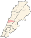
Kahale (Arabic: الكحالة), is a mountain village in the district of Aley (Caza Aley), Lebanon, situated 13 km from Beirut. The population is estimated to be around 11,000 residents, with the majority being Maronite Catholic.[2]
Geography
[edit]Considering the locale and geography of the Kahale this name is suited well. A valley extends from the Sh'har west side of the Kahale into the Rjoum, eastern side of the Kahale.[citation needed]
History
[edit]In 1838, Eli Smith noted the place, called el-Kahhaleh, located in El-Ghurb el-Fokany; Upper el-Ghurb.[3]
Religion
[edit]Kahale has a predominantly Maronite Catholic population.
The village has three churches:
- Mar Elias (مار الياس )
- Our Lady (السيدة)
- Mar Antonios (مار انطونيوس)
This in addition to Don Bosco monastery and school, and Saint Charbel Home for the elderly which is now closed.
References
[edit]- ^ a b Kahhaleh, Localiban
- ^ "التوزيع حسب المذاهب للناخبين/ناخبات في بلدة الكحاله، قضاء عاليه محافظة جبل لبنان في لبنان" [Distribution of voters by sect in the town of Kahaleh, Aley District, Mount Lebanon Governorate, Lebanon]. Lub-anan (in Arabic). Retrieved 16 September 2024.
- ^ Robinson and Smith, 1841, vol 3, 2nd appendix, p. 191
Bibliography
[edit]- Abi Khalil, Charbel. (1997). History of the Kahale. Beirut: The Arabic Press.
- Robinson, E.; Smith, E. (1841). Biblical Researches in Palestine, Mount Sinai and Arabia Petraea: A Journal of Travels in the year 1838. Vol. 3. Boston: Crocker & Brewster.
External links
[edit]Licensed under CC BY-SA 3.0 | Source: https://en.wikipedia.org/wiki/Kahale14 views | Status: cached on March 14 2025 04:03:47↧ Download as ZWI file
 KSF
KSF
