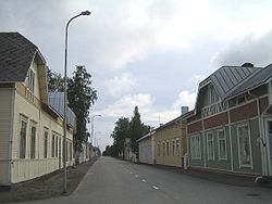
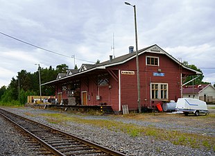
-
Kaskinen Library
-
Kaskinen Church
-
King Gustav Square (Finnish: Kuningas Kustaan aukio)
-
Old freight station of Kaskinen
-
Sälgrund Lighthouse
Kaskinen
 From Wikipedia - Reading time: 11 min
Kaskinen
| |
|---|---|
Town | |
| Kaskisten kaupunki Kaskö stad | |
 Kaskinen | |
 Location of Kaskinen in Finland | |
| Coordinates: 62°22′N 021°15′E / 62.367°N 21.250°E | |
| Country | |
| Region | Ostrobothnia |
| Sub-region | Sydösterbotten |
| Founded | 1785 |
| Government | |
| • Town manager | Markku Lumio |
| Area (2018-01-01)[1] | |
• Total | 175.36 km2 (67.71 sq mi) |
| • Land | 10.64 km2 (4.11 sq mi) |
| • Water | 164.87 km2 (63.66 sq mi) |
| • Rank | 312th largest in Finland |
| Population (2024-10-31)[2] | |
• Total | 1,246 |
| • Rank | 285th largest in Finland |
| • Density | 117.11/km2 (303.3/sq mi) |
| Population by native language | |
| • Finnish | 58.8% (official) |
| • Swedish | 27.5% (official) |
| • Others | 13.7% |
| Population by age | |
| • 0 to 14 | 11.2% |
| • 15 to 64 | 47.1% |
| • 65 or older | 41.7% |
| Time zone | UTC+02:00 (EET) |
| • Summer (DST) | UTC+03:00 (EEST) |
| Unemployment rate | 65% |
| Website | www.kaskinen.fi |
Kaskinen (Finnish: [ˈkɑskinen]; Swedish: Kaskö) is a town and island in Finland, located on the west coast of the country. Kaskinen is situated in Ostrobothnia, along the Gulf of Bothnia. The population of Kaskinen approximately 1,000, while the sub-region has a population of approximately 17,000. It is the 285th most populous municipality in Finland.
Kaskinen covers an area of 10.64 km2 (4.11 sq mi) (excluding sea areas) of which 0.16 km2 (0.062 sq mi) is inland water (1 January 2018).[1] The population density is 117.11/km2 (303.3/sq mi).
Kaskinen is a bilingual municipality with Finnish and Swedish as its official languages. The population consists of 59% Finnish speakers, 27% Swedish speakers, and 14% speakers of other languages, which is well above the national average.
Kaskinen is the smallest municipality in Finland with town status.[6][7] The town is located on an island with two bridges to the mainland, and its only border neighbor is the town of Närpes. The townscape of Kaskinen consists of uniform wooden construction.[7][8] Even though it is planned mainly as a port town, the Suupohja Railway also runs from the town to the Ostrobothnian Railway to Seinäjoki. Today, however, the railway is only used for freight traffic, mainly for the Port of Kaskinen.[9]
The paddle appearing in the coat of arms of Kaskinen describes the excellent natural harbor that has influenced the establishment of the town in its place. The laurel leaf may have been intended to refer to flowering, but its origin may also be in the name of the Bladh family (Swedish: blad, "leaf"); Two members of the family – father and son – acquired both city rights and township status for the village at that time. The coat of arms has been redrawn by A. W. Rancken (1880–1954) based on the old coat of arms, which was originally confirmed on 9 April 1793.[10][11]
Etymology
[edit]The older name forms of Kaskinen island found in the documents are Kaskisöyen (1546), Casköö (1553), Kaskisöö (1573) and the later Kaskin or Kyperäsaari (1844). Although the oldest known written mention of the name Kaskinen for the town dates back to 1863, the name in Finnish is original. This is also indicated by the fact that in old Swedish island names, the body of the name is Kaskis-, to which the explanatory ending -ö has been added, which means island in Swedish. The most likely interpretation of the island's original name is Kaskisaari ("Slash-burn island"), because the slash-and-burn agriculture has therefore been practiced on the island in the early days.[12]
History
[edit]The town was founded in 1785 on an island by King Gustav III of Sweden[7] and since then it has been one of the most important harbours of Finland.[6] In the 18th century, a town plan with long, straight and wide streets was drawn up for the town, and the plan prepared for a clearly larger population; however, even today, there are still many undeveloped estates in the town, and the urban settlement hardly extends beyond the original zoned area.[7][8][13][14]
The rise of the new town was slow in the 19th century, primarily due to poor transport connections. The bridge to the mainland was completed in 1828. As a maritime town, Kaskinen fell behind Kristinestad and Vaasa. Until the 19th century, fishing and trading were the most important livelihoods.[15] During the heyday of the Finnish sailing fleet on both sides of the middle of the 19th century, especially tar and timber were exported from Kaskinen. The town's merchant fleet was at its largest the size of 12 sailing ships. After the era of sailing ships, coastal traffic as well as freight and passenger traffic to Sweden was practiced in the town by steamships.[15]
On 18 November 2019, Kaskinen and Närpes voted for a municipal merger, but Kaskinen's town council voted 9–8 to reject the consolidation.[16][17]
Economy
[edit]In 2015, there were 479 jobs in the municipality. 5,2% of them were in primary production (agriculture, forestry and fisheries), 39,7% in processing and 53,7% in services. The share of processing was higher than in the whole country (20%).[18] In 2016, the companies that paid the most corporate tax were Oy Sonnfish Ab, Kuivaniemen Kala Oy and Kaskitek Oy.[19]
The town includes the Port of Kaskinen, which deals with cargo transport.[20]
Demographics
[edit]The following diagram shows the population development of the town every five years since 1990:
Government
[edit]
At the end of 2017, Minna Nikander was elected the town manager of Kaskinen.[22]
Politics
[edit]The two major parties in Kaskinen are SFP and SDP, which form the majority in elections and in the council. Below are the percentages of support for the parliamentary elections based on the votes cast in the most recent municipal elections:[23][24]
- Swedish People's Party 28.8%
- Social Democratic Party 27.0%
- True Finns 21.4%
- National Coalition Party 12.9%
- Left Alliance 6.7%
- Green League 3.0%
Culture
[edit]Food
[edit]Gubbe ronka or gubbe runka, mashed potato containing salted Baltic herring, served with mashed lingonberry and melted butter, was named as Kaskinen's traditional parish dish in the 1980s.[25][26]
Notable people
[edit]- Rosina Heikel (1842–1929), medical doctor and feminist
- Krista Siegfrids (born 1985), pop singer
- Sune Mangs (1932-1994), actor
Gallery
[edit]See also
[edit]References
[edit]- ^ a b "Area of Finnish Municipalities 1.1.2018" (PDF). National Land Survey of Finland. Retrieved 30 January 2018.
- ^ "Finland's preliminary population figure was 5,635,560 at the end of October 2024". Population structure. Statistics Finland. 19 November 2024. ISSN 1797-5395. Retrieved 22 November 2024.
- ^ "Population growth biggest in nearly 70 years". Population structure. Statistics Finland. 26 April 2024. ISSN 1797-5395. Retrieved 29 April 2024.
- ^ "Population according to age (1-year) and sex by area and the regional division of each statistical reference year, 2003–2020". StatFin. Statistics Finland. Retrieved 2 May 2021.
- ^ a b "Luettelo kuntien ja seurakuntien tuloveroprosenteista vuonna 2023". Tax Administration of Finland. 14 November 2022. Retrieved 7 May 2023.
- ^ a b The Island Town of Artisans, Fishermen and Sailors – Visit Kaskinen
- ^ a b c d Heidi Sommar: Kaskinen ei kasvanutkaan metropoliksi vaan puutaloidylliksi. YLE, April 17, 2015. (in Finnish)
- ^ a b Valtakunnallisesti merkittävät rakennetut kulttuuriympäristot RKY: Kaskisten ruutukaava-alue – Finnish Heritage Agency (in Finnish)
- ^ Niemistö, Elina (8 August 2018). "Kun liikennerahat ovat tiukassa, rahoitusta etsitään kumppanuuksista – Seinäjoen ja Kaskisten välinen Suupohjan rata halutaan uuteen nousuun". YLE (in Finnish). Retrieved 24 July 2022.
- ^ Suomen kunnallisvaakunat (in Finnish). Suomen Kunnallisliitto. 1982. p. 117. ISBN 951-773-085-3.
- ^ Геральдика Великого Княжества Финляндского (in Russian). Запорожье. 2013.
- ^ Sirkka Paikkala (2007). Suomalainen paikannimikirja (in Finnish). Jyväskylä: Kotimaisten kielten tutkimuskeskus. p. 141. ISBN 978-951-593-976-0.
- ^ Kaskö – Kaskinen (in Finnish)
- ^ KASKINEN: ASEMAKAAVARUNGON SELOSTUS (lyhennetty nettiversio) – Tenkanen.net (in Finnish)
- ^ a b Kalevi Rikkinen & Hannes Sihvo (1986). Finlandia: Otavan iso maammekirja 7 (in Finnish). Keuruu: Viiskunta Oy. ISBN 951-1-08930-7.
- ^ Kaakinen, Elina (18 November 2019). "Suomen pienin kaupunki ei taivu kuntaliitokseen – Kaskisten ja Närpiön liitto kaatui tiukan äänestyksen jälkeen" [Finland's smallest town won't agree to a union of municipalities – the union of Kaskinen and Närpes fell after a tight vote!]. Yle (in Finnish). Retrieved 17 September 2022.
- ^ Kääriäinen, Juuso (17 September 2022). "Suomen pienin kaupunki on kohta syönyt säästönsä – 1 300 asukkaan Kaskinen tekee tappiota lähes miljoona euroa vuodessa, mutta kuntaliitos ei kiinnosta" [Finland's smallest town has almost eaten its savings – Kaskinen, with 1,300 inhabitants, makes a loss of almost one million euros a year, but the union of municipalities is not interested!]. Yle (in Finnish). Retrieved 17 September 2022.
- ^ "Kuntien avainluvut" (in Finnish). Statistics Finland. Retrieved 24 July 2022.
- ^ Tebest, Teemo (1 November 2016). "Tässä ovat eniten yhteisöveroa maksaneet yritykset – katso koko maan ja kuntien suurimmat veromaksajat". YLE (in Finnish). Retrieved 24 July 2022.
- ^ "Port of Kaskinen - Quick access to the high seas". Kaskistensatama.fi. Retrieved 24 July 2022.
- ^ "Väestörakenne / 11s5 -- Väkiluku kuukausittain ja alueittain, 1990M01-2020M12" (in Finnish). Statistics Finland. 31 December 2020. Retrieved 24 July 2022.
- ^ "Minna Nikanderista Kaskisten uusi kaupunginjohtaja". Kuntalehti (in Finnish). 23 November 2017. Retrieved 24 July 2022.
- ^ "Eduskuntavaalit 2011 tulospalvelu". Yle (in Finnish). Retrieved 24 July 2022.
- ^ "Kuntavaalit 2021 - Kaskinen". YLE (in Finnish). 16 June 2021. Retrieved 24 July 2022.
- ^ Jaakko Kolmonen (1988). Kotomaamme ruoka-aitta: Suomen, Karjalan ja Petsamon pitäjäruoat (in Finnish). Helsinki: Patakolmonen. p. 156. ISBN 951-96047-3-1.
- ^ Wörlund, Eva (12 February 2015). "Mat från förr smakar än i dag". Hufvudstadsbladet (in Swedish). Retrieved 24 July 2022.
External links
[edit]![]() Media related to Kaskinen at Wikimedia Commons
Media related to Kaskinen at Wikimedia Commons
![]() Kaskinen travel guide from Wikivoyage
Kaskinen travel guide from Wikivoyage
- Town of Kaskinen – Official website
- BBLogistics OY – Official website, operates in Kaskinen Port since 1991
- Map of Kaskinen
 KSF
KSF


