Kowal (town)
 From Wikipedia - Reading time: 8 min
This article needs additional citations for verification. (July 2020) |
Kowal | |
|---|---|
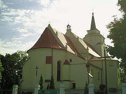
 Church of Saint Ursula | |
| Coordinates: 52°31′57″N 19°8′42″E / 52.53250°N 19.14500°E | |
| Country | |
| Voivodeship | Kuyavian-Pomeranian |
| County | Włocławek |
| Gmina | Kowal (urban gmina) |
| Area | |
• Total | 4.68 km2 (1.81 sq mi) |
| Population (2010)[1] | |
• Total | 3,488 |
| • Density | 750/km2 (1,900/sq mi) |
| Time zone | UTC+1 (CET) |
| • Summer (DST) | UTC+2 (CEST) |
| Postal code | 87-820 |
| Vehicle registration | CWL |
| National road | |
| Voivodeship roads | |
| Website | http://www.kowal.eu/ |
Kowal [ˈkɔval] is a town in Włocławek County, Kuyavian-Pomeranian Voivodeship, Poland, with 3,478 inhabitants (2004).[2]
History
[edit]| Year | Pop. | ±% |
|---|---|---|
| 1897 | 3,993 | — |
| 1921 | 4,063 | +1.8% |
| 1931 | 4,482 | +10.3% |
| 1950 | 3,031 | −32.4% |
| 1960 | 2,983 | −1.6% |
| 2010 | 3,488 | +16.9% |
| Source: [3][4][1] | ||
Kowal was the birthplace of Casimir III the Great, the last Polish King from the Piast dynasty. It was a royal town of the Kingdom of Poland, administratively located in the Brześć Kujawski Voivodeship in the Greater Poland Province.
During the German occupation of Poland (World War II), Kowal was one of the sites of executions of Poles, carried out by the Germans in 1939 as part of the Intelligenzaktion.[5] In 1940, the German gendarmerie carried out expulsions of Poles, who were deported to a transit camp in Łódź and then to the General Government in the more-eastern part of German-occupied Poland, while their houses, shops and workshops were handed over to German colonists as part of the Lebensraum policy.[6]
Transport
[edit]The town is located on Poland's most important north–south highway, National Road 1 (DK1). The town bypass for this road was opened in December, 2007, allowing heavy traffic to avoid the town center. The A1 motorway passes just to the northeast of the town.
Sports
[edit]Its local association football team is Kujawiak Kowal.
Notable people
[edit]The town is the birthplace of
- Casimir III, (1310–1370), King of Poland, 1333 to 1370.[7]
- Max Kowalski (1882—1956) a German composer, singer and singing teacher.
- Dominik Jędrzejewski (1886–1942) martyred Roman Catholic priest
- Jan Nowicki (1939-2022) Polish actor, famous for his role as János in Márta Mészarós "Diaries" trilogy movies
References
[edit]- ^ a b Stan i struktura ludności oraz ruch naturalny w przekroju terytorialnym w 2010 r. (PDF) (in Polish). Warszawa: Główny Urząd Statystyczny. 2011. p. 54. Archived from the original (PDF) on 13 November 2011.
- ^ "Kowal – a charming town in the heart of Poland | Link to Poland". linktopoland.com. Retrieved 2020-09-28.
- ^ Wiadomości Statystyczne Głównego Urzędu Statystycznego (in Polish). Vol. X. Warszawa: Główny Urząd Statystyczny. 1932. p. 198.
- ^ Dokumentacja Geograficzna (in Polish). Vol. 3/4. Warszawa: Instytut Geografii Polskiej Akademii Nauk. 1967. p. 22.
- ^ The Pomeranian Crime 1939. Warsaw: IPN. 2018. p. 42.
- ^ Wardzyńska, Maria (2017). Wysiedlenia ludności polskiej z okupowanych ziem polskich włączonych do III Rzeszy w latach 1939-1945 (in Polish). Warszawa: IPN. pp. 226, 230. ISBN 978-83-8098-174-4.
- ^ Bain, Robert Nisbet (1911). . Encyclopædia Britannica. Vol. 5 (11th ed.). pp. 446–447.
 KSF
KSF


