Lana, South Tyrol
 From Wikipedia - Reading time: 7 min
Lana | |
|---|---|
| Marktgemeinde Lana Comune di Lana | |
 | |
| Coordinates: 46°37′N 11°09′E / 46.617°N 11.150°E | |
| Country | Italy |
| Region | Trentino-Alto Adige/Südtirol |
| Province | South Tyrol (BZ) |
| Frazioni | Fraktionen: Völlan (Foiana), Pawigl (Pavicolo), Ackpfeif (Acquaviva) |
| Government | |
| • Mayor | Helmut Taber (SVP) |
| Area | |
• Total | 36 km2 (14 sq mi) |
| Elevation | 310 m (1,020 ft) |
| Population (Nov. 2010)[2] | |
• Total | 11,206 |
| • Density | 310/km2 (810/sq mi) |
| Demonym(s) | German: Lananer Italian: lanensi |
| Time zone | UTC+1 (CET) |
| • Summer (DST) | UTC+2 (CEST) |
| Postal code | 39011 |
| Dialing code | 0473 |
| Website | Official website |

Lana (Italian pronunciation: [ˈlaːna]; German pronunciation: [ˈlaːna]) is a comune (municipality) and a village in South Tyrol in northern Italy. It is situated in the Etschtal (Etsch Valley) between Bolzano and Merano and at the entrance to the Ultental. The population rose to 12,566 in 2020.
It is one of the three municipalities of South Tyrol whose name remained unchanged by the early 20th-century renaming programme which aimed at replacing mostly German place names with Italianised versions, the other two being Gais and Plaus.[3]
History
[edit]Coat-of-arms
[edit]The emblem displays argent, a Teutonic cross sable, and a lion rampant gules over all. The lion is taken from the arms of the Counts of Brandis who played a role in the development of the village. The emblem was adopted in 1967.[4]
Society
[edit]Linguistic distribution
[edit]According to the 2024 census, 90.14% of Lana's population speak German, 9.53% Italian, and 0.32% Ladin as first language.[5]
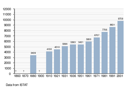
Demographic evolution
[edit]
Notable people
[edit]- Father Joseph Ohrwalder (1856 in Lana - 1913 in Sudan) a Roman Catholic priest, who was taken captive by the Mahdists in Sudan
- Robert Schälzky (1882 – 1948) was the 61st Grand Master of the Teutonic Order 1936 to 1948; he died in Lana
- Hans Andersag (1902–1955) a scientist who discovered chloroquine
- Karl Zuegg (1914 – 2005) an Italian entrepreneur, MD of the Lana fruit juice and jam company Zuegg, between 1940 and 1986
- Armin Zöggeler (born 1974) a retired Italian luger and double Olympic champion, he lives in Lana
Economy
[edit]Tourism
[edit]Lana is a village which is divided into three parts: Oberlana, Mitterlana and Niederlana. It is a popular tourist spot offering sports such as tennis, football, golf, minigolf and ice-skating among others. During summer, locals and tourists alike enjoy swimming, hiking and cycling because there are a lot of good cycle paths.
References
[edit]- ^ "Superficie di Comuni Province e Regioni italiane al 9 ottobre 2011". Italian National Institute of Statistics. Retrieved 16 March 2019.
- ^ "Popolazione Residente al 1° Gennaio 2018". Italian National Institute of Statistics. Retrieved 16 March 2019.
- ^ Olt, Reinhard (28 September 2000). "Am Eisack (Isarco) und an der Etsch (Adige) Namen in Südtirol wecken nationale Leidenschaften". Frankfurter Allgemeine Zeitung. Archived from the original on 14 November 2022. Retrieved 17 March 2012.
- ^ Heraldry of the World: Lana
- ^ "Ergebnisse Sprachgruppenzählung 2024/Risultati Censimento linguistico 2024". astat info (56). Provincial Statistics Institute of the Autonomous Province of South Tyrol. December 2024. Retrieved 2024-12-09.
External links
[edit]![]() Media related to Lana at Wikimedia Commons
Media related to Lana at Wikimedia Commons
- (in German and Italian) Homepage of the municipality
 KSF
KSF


