Langya, Zhejiang
 From Wikipedia - Reading time: 7 min
Langya Town | |
|---|---|
| Chinese transcription(s) | |
| • Simplified | 琅琊镇 |
| • Traditional | 瑯琊鎮 |
| • Pinyin | Lángyá Zhèn |
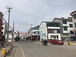
 Main Street of Langya Town. | |
| Coordinates: 29°00′25.56″N 119°29′38.76″E / 29.0071000°N 119.4941000°E | |
| Country | |
| Province | Zhejiang |
| Prefecture | Jinhua |
| China | Wucheng District |
| Area | |
• Total | 98 km2 (38 sq mi) |
| Population (2017) | 18,000 |
| Time zone | UTC+8 (China Standard) |
| Postal code | 321061 |
| Area code | 0579 |
Langya (Chinese: 琅琊镇) is a rural town in Wucheng District of Jinhua, eastern China's Zhejiang province.[1] As of the 2017 census[update] it had a population of 18,000 and an area of 98-square-kilometre (38 sq mi). It is surrounded by Jiangtang Town on the north, Tangxi Town on the west, Bailongqiao Town on the east, and Shafan Township on the south.
History
[edit]In November 2017, it was inscribed to the 5th National Civilized Villages and Towns List.[2]
Geography
[edit]Mount Langfeng (Chinese: 琅峰山) is a mountain in the town.[3]
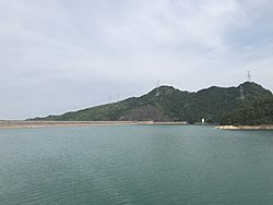
Jinlan Reservoir is the largest body of water in the town.[3]
The Baisha Stream (Chinese: 白沙溪), a tributary of the Jinhua River, flows through the town.[3]
Education
[edit]- Langya School
- Langya Middle School
Attractions
[edit]Baisha Ancient Temple (Chinese: 白沙古庙) is a temple and scenic spot in the town.[3]
Gallery
[edit]References
[edit]- ^ 琅琊镇. zjol.com.cn (in Chinese). 2018-05-25.
- ^ (受权发布)第五届全国文明城市、文明村镇、文明单位和第一届全国文明校园名单. Xinhuanet (in Chinese). 2017-11-17.
- ^ a b c d 【发现·金华】琅琊,你要火!!!. sohu.com (in Chinese). 2018-08-06.
Licensed under CC BY-SA 3.0 | Source: https://en.wikipedia.org/wiki/Langya,_Zhejiang41 views | Status: cached on August 13 2025 10:12:27↧ Download as ZWI file
 KSF
KSF


