Laramie River
 From Wikipedia - Reading time: 4 min
| Laramie River | |
|---|---|
 The Laramie River, as it flows past the site of old Fort Laramie | |
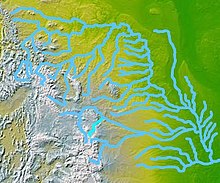
 Map highlighting the Laramie River (in bright blue, below and slightly left of center) | |
| Etymology | Named for Jacques La Ramie, French Canadian fur trapper[1] |
| Location | |
| Country | United States |
| State | Colorado, Wyoming |
| Cities | Laramie, Wheatland, Fort Laramie |
| Physical characteristics | |
| Source | Chambers Lake (Colorado) |
| • location | Larimer County, Colorado |
| • coordinates | 40°36′56″N 105°51′29″W / 40.61556°N 105.85806°W |
| • elevation | 9,192 ft (2,802 m)[2] |
| Mouth | North Platte River |
• location | Goshen County, Wyoming |
• coordinates | 42°11′59″N 104°31′47″W / 42.19972°N 104.52972°W[3] |
• elevation | 4,213 ft (1,284 m)[3] |
| Length | 280 mi (450 km) |
| Basin size | 4,564 sq mi (11,820 km2)[4] |
| Discharge | |
| • location | near Fort Laramie, 0.6 miles (1.0 km) from mouth[4] |
| • average | 129 cu ft/s (3.7 m3/s)[4] |
| • minimum | 0 cu ft/s (0 m3/s) |
| • maximum | 6,260 cu ft/s (177 m3/s) |
| Basin features | |
| Tributaries | |
| • left | North Laramie River |
| • right | Chugwater Creek |
The Laramie River is a tributary of the North Platte River, approximately 280 miles (450 km) long,[5] in the U.S. states of Colorado and Wyoming. The river was named for Jacques La Ramie, a fur trapper who visited the area in the early 19th century. Laramie County, Wyoming, the city of Laramie, and other geographical entities in the region have "Laramie" in their names.[1]
Course
[edit]The river rises in northern Colorado, in the Roosevelt National Forest in the Front Range, in western Larimer County. It flows north-northwest into Wyoming, along the east side of the Medicine Bow Mountains, past Jelm and Woods Landing, then northeast emerging from the mountains 22 miles (35 km) southwest of Laramie. The river then flows north through Laramie. In the Laramie Plains it is joined by the Little Laramie River. The Laramie River then continues north through the Laramie Plains and through Wheatland Reservoir. It flows northeast through the Laramie Mountains. Emerging from the mountains, it receives the North Laramie River 5 miles (8 km) north of Wheatland and Chugwater Creek 7 mi (11 km) northeast of Wheatland. It joins the North Platte opposite the town Fort Laramie.[6]
In its upper reaches in Colorado, the river supplies water to the Cache La Poudre River via the Laramie–Poudre Tunnel. The tunnel, which is approximately 2 miles (3 km) long, was finished in 1911 as part of a larger irrigation project for northern Colorado.[7]
Discharge
[edit]| Statistic | Location | Time period | Discharge |
|---|---|---|---|
| Yearly mean discharge | Near Woods Landing | year | 173 cu ft/s (4.9 m3/s) |
| Near Bosler | year | 150 cu ft/s (4.2 m3/s) | |
| Near Fort Laramie | year | 129 cu ft/s (3.7 m3/s)[4] | |
| Month with highest mean discharge | Near Woods Landing | June | 782 cu ft/s (22.1 m3/s) |
| Near Bosler | June | 726 cu ft/s (20.6 m3/s)[8] | |
| Near Fort Laramie | May | 363 cu ft/s (10.3 m3/s)[4] | |
| Month with lowest mean discharge | Near Woods Landing | January | 38.5 cu ft/s (1.09 m3/s) |
| Near Bosler | September | 31 cu ft/s (0.88 m3/s)[8] | |
| Near Fort Laramie | September | 59.4 cu ft/s (1.68 m3/s)[4] |
See also
[edit]References
[edit]- ^ a b "Story Idea, Name Origins: Cheyenne & Laramie County". Visit Cheyenne. January 1, 2010. Archived from the original on August 28, 2013. Retrieved October 12, 2012.
- ^ Source elevation derived from Google Earth search using GNIS source coordinates.
- ^ a b "Laramie River". Geographic Names Information System. United States Geological Survey. October 13, 1978. Retrieved October 12, 2012.
- ^ a b c d e f "Water-Data Report 2011: 06670500 Laramie River near Fort Laramie, WY" (PDF). United States Geological Survey. Retrieved October 12, 2012.
- ^ U.S. Geological Survey. National Hydrography Dataset high-resolution flowline data. The National Map Archived 2012-03-29 at the Wayback Machine, accessed March 21, 2011
- ^ Wyoming Atlas & Gazetteer. Yarmouth, Maine: DeLorme. 2009. pp. 59–60, 69. ISBN 978-0-89933-338-0.
- ^ "Rehabilitation in the Rocky Mountains" (PDF). Tunnels & Tunnelling International. World Market Intelligence: 22–25. September 2003. Retrieved October 12, 2012.
- ^ a b "USGS 06661585 Laramie River Near Bosler, WY". United States Geological Survey. Retrieved October 12, 2012.
External links
[edit]- . . 1914.
 KSF
KSF