Matendo
 From Wikipedia - Reading time: 6 min
Matendo
Kata ya Matendo (Swahili) | |
|---|---|
| Kata ya Matendo, Wilaya ya Kigoma | |
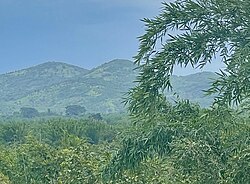
 Landscape in Matendo Ward, Kigoma District | |
| Coordinates: 4°52′25.32″S 29°53′49.56″E / 4.8737000°S 29.8971000°E | |
| Country | |
| Region | Kigoma Region |
| District | Kigoma District |
| Area | |
• Total | 175.4 km2 (67.7 sq mi) |
| Elevation | 969 m (3,179 ft) |
| Population | |
• Total | 14,306 |
| • Density | 82/km2 (210/sq mi) |
| Tanzanian Postal Code | 47209 |
Matendo is an administrative ward in Kigoma District of Kigoma Region in Tanzania. The ward covers an area of 175.4 km2 (67.7 sq mi),[2] and has an average elevation of 969 m (3,179 ft).[3] In 2016, according to the Tanzania National Bureau of Statistics report, there were 14,306 people in the ward, from 22,458 in 2012. Prior to 2014 Kidahwe Ward was a village in the Matendo Ward before splitting off to form its won new ward.[4][1]: 125 [5]: 147
Villages / neighborhoods
[edit]The ward has 3 villages and 12 hamlets.[4]
- Matendo
- Kibalini
- Kibumba
- Kinogodo
- Kumuhama
- Majengo
- Samwa
- Mkuti
- Nyamiaga
- Tunguruza Shuleni
- Pamila
- Mibangani
- Pamila
- Rukaranka
- Samwa
References
[edit]- ^ a b 2016 Makadirio ya Idadi ya Watu katika Majimbo ya Uchaguzi kwa Mwaka 2016, Tanzania Bara [Population Estimates in Administrative Areas for the Year 2016, Mainland Tanzania] (PDF) (Report) (in Swahili). Dar es Salaam, Tanzania: National Bureau of Statistics. 1 April 2016. Archived (PDF) from the original on 27 December 2021. Retrieved 3 July 2022.
- ^ "Tanzania: Lake Zone Tanzania (Districts and Wards) – Population Statistics, Charts and Map".
- ^ "Matendo Elevation".
- ^ a b "Kagera Postcodes" (PDF). Dodoma, Tanzania: Tanzania Communications Regulatory Authority. Archived (PDF) from the original on 29 July 2022. Retrieved 13 August 2022.
- ^ 2012 Population and Housing Census - Population Distribution by Administrative Areas (PDF) (Report). Dar es Salaam, Tanzania: National Bureau of Statistics. 1 March 2013. Archived (PDF) from the original on 26 March 2022. Retrieved 3 July 2022.
Licensed under CC BY-SA 3.0 | Source: https://en.wikipedia.org/wiki/Matendo16 views | Status: cached on July 01 2025 13:28:15↧ Download as ZWI file
 KSF
KSF