Categories
Mendel Glacier
 From Wikipedia - Reading time: 5 min
| Mendel Glacier | |
|---|---|
 Mendel Glacier Location in California | |
| Type | Mountain glacier |
| Location | Kings Canyon National Park, Fresno County, California, United States |
| Coordinates | 37°10′42″N 118°40′58″W / 37.17833°N 118.68278°W |
| Length | .10 mi (0.16 km) |
| Terminus | Talus |
| Status | Retreating |
Mendel Glacier is on the north side of Mount Mendel in the Sierra Nevada, California.[1] The name is commonly used; however, the name is not recognized by the United States Geological Survey in the Geographic Names Information System. Mendel Glacier is .35 miles (0.56 km) north of Darwin Glacier at 12,500 feet (3,800 m) above sea level.
The middle and lower portions of the glacier are covered with rock debris.
A US Army plane crashed above or into the glacier in 1942 with four airmen on board during a navigation training mission.[2]
-
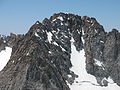 Upper Mendel Glacier July, 2006
 -
 Mendel Glacier Terminus July, 2006


See also
[edit]References
[edit]- ^ Mount Darwin, CA (Map). TopoQwest (United States Geological Survey Maps). Retrieved September 30, 2012.
- ^ Stekel, Peter. "Final Flight". Wilderness Press. Retrieved March 16, 2010.
This Fresno County, California-related article is a stub. You can help Wikipedia by expanding it. |
This article about a glacier in the United States is a stub. You can help Wikipedia by expanding it. |
Licensed under CC BY-SA 3.0 | Source: https://en.wikipedia.org/wiki/Mendel_Glacier8 views | ↧ Download as ZWI file
 EncycloReader
is supported by the
EncycloReader
is supported by the