Midden-Drenthe
 From Wikipedia - Reading time: 7 min
Midden-Drenthe | |
|---|---|
 Canal through Midden-Drenthe | |
 Location in Drenthe | |
| Coordinates: 52°52′N 6°31′E / 52.867°N 6.517°E | |
| Country | Netherlands |
| Province | Drenthe |
| Established | 1 January 1998[1] |
| Renamed | 1 January 2000[2] |
| Government | |
| • Body | Municipal council |
| • Mayor | Mieke Damsma (D66) |
| Area | |
• Total | 345.87 km2 (133.54 sq mi) |
| • Land | 340.51 km2 (131.47 sq mi) |
| • Water | 5.36 km2 (2.07 sq mi) |
| Elevation | 14 m (46 ft) |
| Population (January 2021)[6] | |
• Total | 33,381 |
| • Density | 98/km2 (250/sq mi) |
| Time zone | UTC+1 (CET) |
| • Summer (DST) | UTC+2 (CEST) |
| Postcode | 7938, 9410–9442 |
| Area code | 0528, 0592, 0593 |
| Website | www |
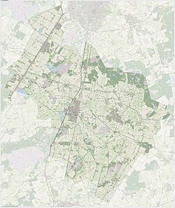
 Dutch Topographic map of the municipality of Midden-Drenthe, June 2015
 | |
Midden-Drenthe (Dutch pronunciation: [ˌmɪdə(n) ˈdrɛntə] ⓘ) is a municipality in the northeastern Netherlands. The municipality was created in 1998, in a merger of the former municipalities of Beilen, Smilde, and Westerbork. Between 1998 and 2000, the name of the municipality was Middenveld.
Population centres
[edit]
The village of Westerbork gives its name to the Westerbork deportation and (later) concentration camp, located about 7 km north of the village, in the forests of Hooghalen.
The Westerbork Synthesis Radio Telescope (WSRT) array was installed near the site of the camp in 1969.
Education
[edit]There are 16 primary schools in the municipality as of 2023.[7]
There are two secondary schools, both in Beilen:[7]
- Dr. Nassau College
- CS Vincent van Gogh
Notable people
[edit]- Carry van Bruggen (1881 in Smilde - 1932) a Dutch writer
- Jacob Israël de Haan (1881 in Smilde – 1924 in Jerusalem) a Dutch-Jewish literary writer, jurist and journalist, killed by Haganah
- Jan Hartman (1887 in Beilen – 1969) a Dutch fascist and collaborator during WWII
- Hendrikje van Andel-Schipper (1890 in Smilde – 2005 in Hoogeveen) the oldest person ever from the Netherlands
- Hans Heyting (1918 near Beilen – 1992) a Dutch poet, playwright, radio personality, children's book writer and painter
- Henk Koning (1933 in Beilen – 2016) a Dutch politician
- Martin van Hees (born 1964 in Beilen) a Dutch philosopher and academic
- Eef van Breen (born 1978 in Westerbork) a Dutch jazz trumpeter, singer, arranger and composer
Sport
[edit]- Jan Lomulder (born 1967 in Beilen) a Dutch former kickboxer
- Adelinde Cornelissen (born 1979 in Beilen) a Dutch dressage rider
- Jasper Iwema (born 1989 in Hooghalen) a Dutch motorcycle rider
- Laura Dijkema (born 1990 in Beilen) a Dutch volleyball player
References
[edit]- ^ "Gemeentelijke indeling op 1 januari 1998" [Municipal divisions on 1 January 1998]. cbs.nl (in Dutch). CBS. Retrieved 10 October 2013.
- ^ "Gemeentelijke indeling op 1 januari 2000" [Municipal divisions on 1 January 2000]. cbs.nl (in Dutch). CBS. Retrieved 10 October 2013.
- ^ "Leden college van burgemeester en wethouders" [Members of the board of mayor and aldermen] (in Dutch). Gemeente Midden-Drenthe. Archived from the original on 16 April 2011. Retrieved 10 October 2013.
- ^ "Kerncijfers wijken en buurten 2020" [Key figures for neighbourhoods 2020]. StatLine (in Dutch). CBS. 24 July 2020. Retrieved 19 September 2020.
- ^ "Postcodetool for 9411NB". Actueel Hoogtebestand Nederland (in Dutch). Het Waterschapshuis. Archived from the original on 21 September 2013. Retrieved 10 October 2013.
- ^ "Bevolkingsontwikkeling; regio per maand" [Population growth; regions per month]. CBS Statline (in Dutch). CBS. 1 January 2021. Retrieved 2 January 2022.
- ^ a b "Scholen" (in Dutch). Midden-Drenthe. Retrieved 2023-04-15.
External links
[edit]
Licensed under CC BY-SA 3.0 | Source: https://en.wikipedia.org/wiki/Midden-Drenthe30 views | Status: cached on August 16 2025 20:57:13↧ Download as ZWI file
 KSF
KSF

