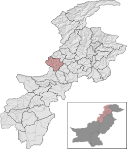
Mohmand District
 From Wikipedia - Reading time: 8 min
This article needs additional citations for verification. (July 2015) |
Mohmand District
ضلع مہمند مومندو ولسوالۍ Mohmand Agency مہمند ایجنسی مومندو ایجنسئ | |
|---|---|
 Mohmand District (red) in Khyber Pakhtunkhwa | |
| Country | |
| Province | |
| Division | Peshawar |
| Established | 1951 (as an agency of Federally Administered Tribal Areas) |
| Headquarters | Ghalanai |
| Number of Tehsils | 7 |
| Government | |
| • Type | District Administration |
| • Deputy Commissioner | Mr. Arifullah Awan (BPS-18 PAS) |
| • District Police Officer | Muhammad Ayyaz (BPS-18 PSP) |
| • District Health Officer | N/A |
| Area | |
| 2,296 km2 (886 sq mi) | |
| Population (2023)[1] | |
| 553,933 | |
| • Density | 240/km2 (620/sq mi) |
| • Urban | 0 |
| • Rural | 553,933 |
| Literacy | |
| • Literacy rate |
|
| Time zone | UTC+5 (PST) |
| Main language(s) | Pashto[1] |
| Website | mohmand |
Mohmand District (Pashto: مومندو ولسوالۍ, Urdu: ضلع مہمند) is a district in Peshawar Division of Khyber Pakhtunkhwa province in Pakistan. Until 2018, it was an agency of Federally Administered Tribal Areas, with merger of FATA with Khyber Pakhtunkhwa, it became a district. It was created as an agency in 1951. Mohmand is bordered by Bajaur District to the north, Khyber District to the south, Malakand and Charsadda districts to the east and Peshawar district to the southeast.
Mr. Arif Ullah Awan (PAS) is the current Deputy Commissioner of Mohmand District.[3]
Administration
[edit]Mohmand District is currently subdivided into seven Tehsils:[4]
- Ambar Utmankhel Tehsil (Urdu: تحصیل امبر اتمان خیل)(Pashto: امبر اتمان خېل تحصیل)
- Halim Zai Tehsil (Urdu: تحصیل حلیم زئی)(Pashto: حلیمزي تحصیل)
- Pindiali Tehsil (Urdu: تحصیل پنڈیالی)(Pashto: پنډیالي تحصیل)
- Prang Ghar Tehsil (Urdu: تحصیل پڑانگ غار)(Pashto: پړانګ غار تحصیل)
- Safi Tehsil (Urdu: تحصیل صافی)(Pashto: صافي تحصیل)
- Upper Mohmand Tehsil (Urdu: تحصیل مہمند بالا)(Pashto: پورتنۍ مومندو تحصیل)
- Yake Ghund Tehsil (Urdu: تحصیل یکہ غنڈ)(Pashto: یکه غنډ تحصیل)
Provincial Assembly
[edit]| Member of Provincial Assembly | Party Affiliation | Constituency | Year |
|---|---|---|---|
| Mehboob Sher | Pakistan Tehreek-e-Insaf | PK-67 Mohmand-I | 2024 |
| Nisar Mohmand | Awami National Party | PK-64 Mohmand-I | 2019 |
| Malik Abbas Rehman | Balochistan Awami Party | PK-65 Mohmand-II |
Demographics
[edit]| Year | Pop. | ±% p.a. |
|---|---|---|
| 1951 | 129,300 | — |
| 1961 | 294,215 | +8.57% |
| 1972 | 382,922 | +2.42% |
| 1981 | 163,933 | −9.00% |
| 1998 | 334,453 | +4.28% |
| 2017 | 474,345 | +1.86% |
| 2023 | 553,933 | +2.62% |
| Sources:[5][1] | ||
As of the 2023 census, Mohmand district has 63,973 households and a population of 553,933. The district has a sex ratio of 103.24 males to 100 females and a literacy rate of 31.28%: 46.85% for males and 15.10% for females. 191,753 (34.62% of the surveyed population) are under 10 years of age. The entire population lives in rural areas.[1] 1,592 (0.29%) people in the district were from religious minorities, mainly Christians.[6] Pashto was the predominant language, spoken by 99.80% of the population.[7]
War on Terror
[edit]Despite its attraction for tourists, Mohmand District has been an area of conflict between Pakistan Army and some militant groups.[8]
On September 16, 2011, security forces cleared ninety percent of Mohmand District from the militants, normal life was restored and development activities were launched.[9]
In 2012, the Pakistani Army declared full control of Mohmand District and de-notified it as a conflict zone and transferred its control to the Frontier Corps.[10] However, terrorists continue to pose threat to the peace by launching scattered terrorist attacks across from the Pakistan-Afghanistan border.
2020 Marble Mine Incident
[edit]In Safi Tehsil a marble mine collapsed and killed at least 19 people and more than 20 people were also injured.
See also
[edit]References
[edit]- ^ a b c d "7th Population and Housing Census - Detailed Results: Table 1" (PDF). www.pbscensus.gov.pk. Pakistan Bureau of Statistics.
- ^ "Literacy rate, enrolments, and out-of-school population by sex and rural/urban, CENSUS-2023, KPK" (PDF).
- ^ "Pakistan suicide bomb attack kills dozens". BBC News. London, UK. 6 December 2010.
- ^ "DISTRICT AND TEHSIL LEVEL POPULATION SUMMARY WITH REGION BREAKUP [PDF]" (PDF). www.pbscensus.gov.pk. 3 January 2018. Archived from the original (PDF) on 26 March 2018. Retrieved 25 March 2018.
- ^ "Population by administrative units 1951-1998" (PDF). Pakistan Bureau of Statistics.
- ^ "7th Population and Housing Census - Detailed Results: Table 9" (PDF). Pakistan Bureau of Statistics.
- ^ "7th Population and Housing Census - Detailed Results: Table 11" (PDF). Pakistan Bureau of Statistics.
- ^ Fida, Noman (14 April 2011). "Forces Kill 18 militants in Mohmand District". The News Tribe. Bradford, UK.
- ^ "90% of Mohmand District cleared of militants; IDPs return home". The Nation. Lahore, Pakistan: Nawa-i-Waqt. 16 September 2011. Archived from the original on 28 September 2011. Retrieved 9 April 2018.
- ^ Ali, Zulfiqar (6 August 2012). "South Waziristan operation: Only Sararogha cleared in three years". Dawn. Karachi, Pakistan: Pakistan Herald Publications.
 KSF
KSF

