Mukims of Brunei
 From Wikipedia - Reading time: 7 min
| this article is part of a series on the |
| politics of Brunei Darussalam |
|---|
 |
|
|
| administrative divisions of Brunei Darussalam |
|---|
| first-level |
| District |
| second-level |
| Mukim |
| third-level |
| Village |
| outside of hierarchy |
| Municipality |

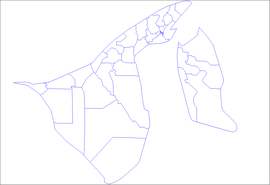
A mukim is a second-level administrative division of Brunei Darussalam, and the primary sub-division of a larger district (daerah). There are thirty-nine mukims within the four districts of the sultanate Brunei Darussalam. A mukim is led by a penghulu, since 2015 elected by democratic vote. A mukim encompasses a number of villages, known in Malay as kampung or kampong.[1] Mukims are administered by the district office of the district where they are located.
List of mukims
[edit]| mukim | district | population (2021)[2] |
map |
|---|---|---|---|
| Berakas 'A' | Brunei-Muara[3] | 28,311 |  (note that Gadong 'A' and 'B' are shown as one entity) |
| Berakas 'B' | 39,284 | ||
| Burong Pingai Ayer | 1,459 | ||
| Gadong 'A' | 35,424 | ||
| Gadong 'B' | 38,067 | ||
| Kianggeh | 8,102 | ||
| Kilanas | 24,981 | ||
| Kota Batu | 12,676 | ||
| Lumapas | 8,058 | ||
| Mentiri | 39,324 | ||
| Pangkalan Batu | 15,860 | ||
| Peramu | 1,151 | ||
| Saba | 827 | ||
| Sengkurong | 40,972 | ||
| Serasa | 18,569 | ||
| Sungai Kebun | 4,282 | ||
| Sungai Kedayan | 241 | ||
| Tamoi | 942 | ||
| Bukit Sawat | Belait[4] | 759 | 
|
| Kuala Balai | 16 | ||
| Kuala Belait | 28,793 | ||
| Labi | 727 | ||
| Liang | 16,813 | ||
| Melilas | 29 | ||
| Seria | 18,313 | ||
| Sukang | 81 | ||
| Keriam | Tutong[1] | 8,589 | 
|
| Kiudang | 5,063 | ||
| Lamunin | 3,641 | ||
| Pekan Tutong | 9,883 | ||
| Rambai | 980 | ||
| Tanjong Maya | 3,772 | ||
| Telisai | 13,253 | ||
| Ukong | 2,029 | ||
| Amo | Temburong[5] | 1,667 | 
|
| Bangar | 2,112 | ||
| Batu Apoi | 1,355 | ||
| Bokok | 3,812 | ||
| Labu | 508 |
References
[edit]- ^ a b "Tutong District" (PDF). Information.gov.bn. Old Airport, Berakas, BB3510: Information Department, Prime Minister's Office, Brunei Darussalam. pp. 7–9. Retrieved 1 March 2018.
{{cite web}}: CS1 maint: location (link) - ^ "Annex B" (PDF). DEPS.MoFE.gov.bn. Department of Economic Planning and Statistics, Ministry of Finance and Economy. October 2021. Retrieved 23 January 2024.
- ^ "Brunei-Muara District" (PDF). Information.gov.bn. Old Airport, Berakas, BB3510: Information Department, Prime Minister's Office, Brunei Darussalam. p. 8. Retrieved 1 March 2018.
{{cite web}}: CS1 maint: location (link) - ^ "Belait District" (PDF). Information.gov.bn. Old Airport, Berakas, BB3510: Information Department, Prime Minister's Office, Brunei Darussalam. pp. 8–9. Retrieved 1 March 2018.
{{cite web}}: CS1 maint: location (link) - ^ "Temburong District" (PDF). Information.gov.bn. Old Airport, Berakas, BB3510: Information Department, Prime Minister's Office, Brunei Darussalam. p. 8. Retrieved 1 March 2018.
{{cite web}}: CS1 maint: location (link)
External links
[edit]![]() Media related to Mukims of Brunei at Wikimedia Commons
Media related to Mukims of Brunei at Wikimedia Commons
Licensed under CC BY-SA 3.0 | Source: https://en.wikipedia.org/wiki/Mukims_of_Brunei9 views | Status: cached on December 10 2024 14:21:38↧ Download as ZWI file
 KSF
KSF