Pljevlja Municipality
 From Wikipedia - Reading time: 7 min
Pljevlja Municipality
Opština Pljevlja Општина Пљевља | |
|---|---|
 Flag  Coat of arms | |
.svg) Pljevlja Municipality in Montenegro | |
| Coordinates: 43°21′00″N 19°21′00″E / 43.3500°N 19.3500°E | |
| Country | Montenegro |
| Seat | Pljevlja |
| Area | |
• Total | 1,346 km2 (520 sq mi) |
| Population (2011 Census) | |
• Total | 30,786 |
| • Density | 23/km2 (59/sq mi) |
| Time zone | UTC+1 |
| • Summer (DST) | UTC+2 (CEST) |
| Area code | +382 52 |
| ISO 3166-2 code | ME-14 |
| Car plates | PV |
| Climate | Cfb |
| Website | http://www.pljevlja.me/ |
Pljevlja Municipality is located in Northern Montenegro. It covers an area of 1,346 km² and had a population of 30,786 at the 2011 census.[1]
Geography and location
[edit]The highest point of the municipality is on the Ljubišnja mountain at an altitude of 2,238 m (7,343 ft), while the lowest point is in the canyon of the Tara river with an altitude of 529 m (1,736 ft) above sea level. The municipality borders the municipalities of: Žabljak, Bijelo Polje and Mojkovac in Montenegro, as well as the countries of Serbia and Bosnia and Herzegovina. With a total area of 1,346 km2 (520 sq mi), it is the third largest municipality in Montenegro.
Demographics
[edit]The town of Pljevlja is the administrative center of the Pljevlja municipality, which has a population of 35,806. The town of Pljevlja itself has 19,136 residents, and is the only town in the municipality with a population of over 1,000. The municipality has a Serb majority. According to the 2011 census, the population consisted of: Serbs (60.11%), Montenegrins (21.52%), Muslims (8.14%) and Bosniaks (5.21%).[2]
Settlements
[edit]- Aliži
- Beljkovići
- Bjeloševina
- Bobovo
- Boljanići
- Borišići
- Borova
- Borovica
- Boščinovići
- Brda, Pljevlja
- Bujaci
- Bušnje
- Čardak
- Čavanj
- Čerjenci
- Cerovci
- Čestin
- Crljenice
- Crni Vrh, Pljevlja
- Crno Brdo
- Crnobori
- Donja Brvenica
- Dragaši, Pljevlja
- Dubac
- Dubočica
- Dubrava, Pljevlja
- Đuli
- Đurđevića Tara
- Durutovići
- Dužice
- Geuši
- Glibaći
- Glisnica
- Gornja Brvenica
- Gornje Selo
- Gotovuša
- Gradac, Pljevlja
- Gradina, Pljevlja
- Grevo
- Horevina
- Hoćevina
- Jabuka, Pljevlja
- Jagodni Do
- Jahovići
- Jasen
- Jugovo
- Kakmuži
- Kalušići
- Katun, Pljevlja
- Klakorina
- Kolijevka
- Komine
- Kordovina
- Kosanica
- Kotlajići
- Kotline
- Kotorac
- Kovačevići
- Kovači, Pljevlja
- Kozica, Pljevlja
- Košare
- Krupice
- Kruševo, Pljevlja
- Krćevina
- Kržava
- Kukavica, Pljevlja
- Lađana
- Leovo Brdo
- Lever Tara
- Lijeska, Pljevlja
- Ljutići
- Ljuće
- Lugovi, Pljevlja
- Madžari
- Male Krće
- Maoče
- Mataruge
- Meljak
- Metaljka
- Mijakovići
- Milakovići
- Milunići
- Mironići
- Moraice
- Moćevići
- Mrzovići
- Mrčevo
- Mrčići
- Nange
- Obarde
- Odžak
- Ograđenica
- Orlja, Pljevlja
- Otilovići
- Pauče
- Petine
- Pižure
- Plakala
- Planjsko
- Pliješ
- Pliješevina
- Poblaće
- Podborova
- Popov Do
- Potkovač
- Potkrajci, Pljevlja
- Potoci, Pljevlja
- Potpeće, Pljevlja
- Potrlica
- Pračica
- Prehari
- Premćani
- Prisoji
- Prošće
- Pušanjski Do
- Rabitlje
- Rađevići
- Romac
- Rudnica, Pljevlja
- Rujevica, Pljevlja
- Selac
- Selišta, Pljevlja
- Sirčići
- Slatina, Pljevlja
- Šljivansko, Pljevlja
- Šljuke
- Srećanje
- Stančani
- Strahov Do
- Šula
- Šumani
- Tatarovina
- Trnovice
- Tvrdakovići
- Uremovići
- Varine
- Vaškovo
- Velike Krće
- Vidre, Pljevlja
- Vijenac
- Vilići
- Višnjica
- Vodno
- Vojtina
- Vrba, Pljevlja
- Vrbica, Pljevlja
- Vrulja
- Zabrđe, Pljevlja
- Zaselje, Pljevlja
- Zbljevo
- Zekavice
- Zenica, Pljevlja
- Židovići
- Zorlovići
City Assembly
[edit]| Party/Coalition | Seats | Local Gov't. | |
|---|---|---|---|
| ZBCG (NSD–DNP) | 12 / 34
|
Yes | |
| DPS | 8 / 34
|
No | |
| DCG | 4 / 34
|
Yes | |
| PES | 4 / 34
|
Yes | |
| Pokret za Pljevlja | 2 / 34
|
Yes | |
| SNP | 1 / 34
|
Yes | |
| URA | 1 / 34
|
No | |
| SEP | 1 / 34
|
No | |
| BS | 1 / 34
|
No | |
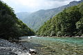
Gallery
[edit]-
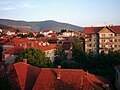 Town of Pljevlja
 -

-

-
-

-

-
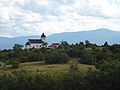 Church near Pljevlja
 -


.jpg)


References
[edit]- ^ Opštine u Crnoj Gori Archived 2022-01-22 at the Wayback Machine, Ministarstvo javne uprave (MJU), Vlada Crne Gore
- ^ http://www.monstat.org/userfiles/file/popis2011/saopstenje/saopstenje%281%29.pdf [bare URL PDF]
| Capital City | ||
|---|---|---|
| Old Royal Capital | ||
| Municipalities | ||
| Authority control databases: Geographic |
|---|
 EncycloReader
is supported by the
EncycloReader
is supported by the