Po Keng Teng
 From Wikipedia - Reading time: 8 min
| Po Keng Teng | |
|---|---|
| 寶鏡頂 | |
 View of Po Keng Teng in Clear Water Bay Peninsula | |
| Highest point | |
| Elevation | 127 m (417 ft) |
| Coordinates | 22°15′59″N 114°18′19″E / 22.26639°N 114.30528°E |
| Geography | |
| Location | |
Po Keng Teng (Chinese: 寶鏡頂) is a mountain inside Clear Water Bay Country Park, Sai Kung, New Territories, Hong Kong, with a height of 127 metres (417 ft).[1][2]
Geography
[edit]Po Keng Teng is in the Clear Water Bay Peninsula region. To the west is a golf club.
There are no public roads that lead to the mountain because a private golf club separates it from the nearest public road. The trails to the summit are rather rocky, and not maintained by the government, so proper hiking footwear is advisable. The cliff on its east side is very steep.
Geology
[edit]
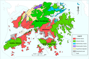
Po Keng Teng is formed by volcanic rocks, like many of the tallest mountains in Hong Kong, such as Tai Mo Shan. Some shorter mountains in Hong Kong are formed by older granitic rocks.
References
[edit]- ^ "po keng teng". OpenStreetMap. Retrieved 19 November 2021.
- ^ "Trigonmetrical Station Summary" (PDF).
See also
[edit]Wikimedia Commons has media related to High Junk Peak.
Licensed under CC BY-SA 3.0 | Source: https://en.wikipedia.org/wiki/Po_Keng_Teng9 views | Status: cached on November 24 2024 09:59:46↧ Download as ZWI file
 KSF
KSF