Sävar
 From Wikipedia - Reading time: 6 min
Sävar | |
|---|---|
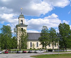
 Sävar Church in June 2007 | |
| Coordinates: 63°54′N 20°34′E / 63.900°N 20.567°E | |
| Country | Sweden |
| Province | Västerbotten |
| County | Västerbotten County |
| Municipality | Umeå Municipality |
| Area | |
• Total | 2.45 km2 (0.95 sq mi) |
| Population (31 December 2010)[1] | |
• Total | 2,670 |
| • Density | 1,092/km2 (2,830/sq mi) |
| Time zone | UTC+1 (CET) |
| • Summer (DST) | UTC+2 (CEST) |
Sävar (Swedish pronunciation: [ˈsɛ̂ːvar])[2] is a locality situated in Umeå Municipality, Västerbotten County, Sweden with 2,670 inhabitants in 2010.[1]
It is located by E4 about 15 km north of Umeå, Sweden, and is mostly known for being the last battlefield of the Finnish War.
References
[edit]- ^ a b c "Tätorternas landareal, folkmängd och invånare per km2 2005 och 2010" (in Swedish). Statistics Sweden. 14 December 2011. Archived from the original on 27 January 2012. Retrieved 10 January 2012.
- ^ Jöran Sahlgren; Gösta Bergman (1979). Svenska ortnamn med uttalsuppgifter (in Swedish). p. 24.
Licensed under CC BY-SA 3.0 | Source: https://en.wikipedia.org/wiki/Sävar17 views | Status: cached on August 18 2025 06:53:44↧ Download as ZWI file
 KSF
KSF
