San Bartolome District
 From Wikipedia - Reading time: 5 min
San Bartolome | |
|---|---|
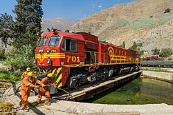
 Locomotive on the turntable at San Bartolomé, Peru | |
 | |
| Country | |
| Region | Lima |
| Province | Huarochirí |
| Founded | November 9, 1953 |
| Capital | San Bartolome |
| Government | |
| • Mayor | Rodrigo Enrique Chavez Vivas |
| Area | |
• Total | 43.91 km2 (16.95 sq mi) |
| Elevation | 1,600 m (5,200 ft) |
| Population (2017) | |
• Total | 1,139 |
| • Density | 26/km2 (67/sq mi) |
| Time zone | UTC-5 (PET) |
| UBIGEO | 150717 |
San Bartolome District is one of thirty-two districts of the Huarochirí Province, located in the Department of Lima in Peru.[1] The district was created by the Law No. 12001 in November 9, 1953, during the presidency of Manuel A. Odría. It encompasses an area of 43.91 km2.
km2 References
[edit]- ^ (in Spanish) Instituto Nacional de Estadística e Informática. Banco de Información Distrital Archived 2008-04-23 at the Wayback Machine. Retrieved April 11, 2008.
Licensed under CC BY-SA 3.0 | Source: https://en.wikipedia.org/wiki/San_Bartolome_District9 views | Status: cached on November 27 2024 23:42:28↧ Download as ZWI file
 KSF
KSF