Sauer (Rhine)
 From Wikipedia - Reading time: 7 min
This article relies largely or entirely on a single source. (December 2021) |
| Sauer | |
|---|---|
 | |
| Location | |
| Countries | Germany and France |
| Physical characteristics | |
| Source | |
| • location | Palatine Forest |
| Mouth | |
• location | Rhine |
• coordinates | 48°54′55″N 8°9′25″E / 48.91528°N 8.15694°E |
| Length | ~85 km (53 mi) |
| Basin features | |
| Progression | Rhine→ North Sea |
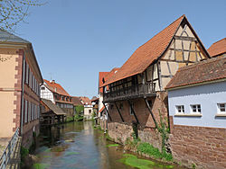
The Sauer is a river in France (Alsace) and Germany (Rhineland-Palatinate). A left tributary of the river Rhine, its total length is about 85 kilometres (53 mi), of which 64 km (40 mi) in France.[1] Its upper course, in Germany, is called Saarbach. Its source is in the Palatinate forest, near the French border, south of Pirmasens. It flows into France near Schœnau, and continues through Wœrth and north of Haguenau. It flows into the Rhine in Seltz, opposite the mouth of the Murg.
Tributaries
[edit]References
[edit]
Licensed under CC BY-SA 3.0 | Source: https://en.wikipedia.org/wiki/Sauer_(Rhine)15 views | Status: cached on August 10 2025 16:34:08↧ Download as ZWI file
 KSF
KSF

