Savannah Region
 From Wikipedia - Reading time: 10 min
Savannah Region | |
|---|---|
 Larabanga Mosque, one of the oldest mosques in West Africa | |
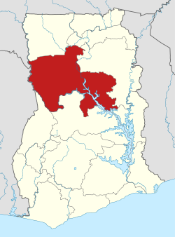
 Location of Savannah Region in Ghana | |
| Country | Ghana |
| Capital | Damongo |
| Districts | 6 |
| Government | |
| • Regional Minister | Salisu Be-Awuribe |
| Area | |
• Total | 35,862 km2 (13,846 sq mi) |
| Population (2021 Census)[4] | |
• Total | 653,266[3] |
| • Density | 18/km2 (50/sq mi) |
| Time zone | GMT |
| Area code | 037 |
| ISO 3166 code | GH-SV |
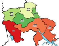
The Savannah Region is one of the newest regions of Ghana and yet the largest region in the country. The creation of the Region follows presentation of a petition by the Gonja Traditional Council, led by the Yagbonwura Tumtumba Boresa Jakpa I. Upon receiving favourable responses from all stakeholders in the Northern Region (the region it was broken off from), the Brobbey Commission (the Commission tasked with the creation of the new regions), a referendum was conducted on the 27th December 2018.[5] The result was a resounding yes of 99.7%. The President of the Republic of Ghana signed and presented the Constitutional Instrument (CI) 115 to the Yagbonwura in the Jubilee House, Accra on 12 February 2019. The launch was well attended by sons and daughters of Gonjaland including all current and past Mps, MDCEs and all appointees with Gonjaland descent. Damongo was declared the capital of the new Savannah Region.[6] It is located in the north of the country. The Savannah Region is divided into 7 districts; Bole, Central Gonja, North Gonja, East Gonja, Sawla/Tuna/Kalba, West Gonja, North East Gonja and 7 Constituencies; Bole/Bamboi, Damongo, Daboya/Mankarigu, Salaga North, Salaga South, Sawla/Tuna/Kalba and Yapei/Kusawgu.[7][8] The capital of Bole district is Bole; East Gonja municipal is Salaga; West Gonja district is Damango; Sawla Tuna Kalba district is Salwa; Central Gonja is Buipe; North Gonja is Daboya; and North East Gonja is Kpalbe[9]
History
[edit]Prior to the 2016 Ghanaian general election, the then candidate Nana Akufo-Addo declared that when elected, he would explore the possibility of creating new regions out of some of the existing regions in Ghana in order to bring government closer to citizens.
The execution of plans for the creation of the regions was seeded to the newly created Ministry of Regional Reorganization and Development[10] which is under the leadership of Hon. Dan Botwe. Government of Ghana ministry charged with the responsibility of supervising the creation of new regions in Ghana.[10] In March 2017, the ministry sent the blue print for the creation of the region along with others to the Council of State. The council met over 36 times from the time of submission to August 2017.[11]
The final stage for the creation of the region will be decided through a referendum by the people within the catchment of the new region.[12]
A referendum on 27 December 2018[13] approved the creation of Savannah Region, with 206,350 (99.52%) votes in favour on a turnout of 81.77%.[14][15][16] CI 115 establishing the Region signed and presented on 12 February 2019.[17]
Geography and climate
[edit]Location and size
[edit]The Savannah Region is bordered on the north by the Upper West region, on the west by the Ghana-Côte d'Ivoire international border, on the south by the Bono and Bono East regions, and on the west by the North East and Northern regions. Savannah region is made up of 7 districts.
Health facilities
[edit]- West Gonja Hospital[18]
- St. Anne’s Catholic Hospital[18]
- Salaga District Hospital[18]
- Bole District Hospital[18]
- Sawla-Tuna Kalbe District Hospital[18]
- Central Gonja District Hospital[18]
Climate and vegetation
[edit]The Savannah Region is much drier than southern areas of Ghana, due to its proximity to the Sahel, and the Sahara. The vegetation consists predominantly of grassland, especially savanna with clusters of drought-resistant trees such as baobabs or acacias. Between December and April is the dry season. The wet season is between about July and November with an average annual rainfall of 750 to 1050 mm (30 to 40 inches). The highest temperatures are reached at the end of the dry season, the lowest in December and January. However, the hot Harmattan wind from the Sahara blows frequently between December and the beginning of February. The temperatures can vary between 14 °C (59 °F) at night and 40 °C (104 °F) during the day.
Tourism & Parks
[edit]
- Mole National Park
- Salaga slave market and wells
- Bui National Park[19] (now defunct due to Bui National Dam)
- Larabanga Historic Mosque[20]
- Wechiau Hippo Sanctuary[21]
Business and Investment
[edit]It is one of the main grain and tuber producing areas in Ghana. Harnessing these particularly will help to create employment and reduce poverty. The Region has about 2.69 million hectares of land under cropping and livestock rearing.
It has unique climatic and soil characteristic making the area ideal for growing of pineapples (number one non- traditional export crop in Ghana), yams (second most important non-traditional export crop) cassava and maize.[22]
Demographics
[edit]The Savannah Region has a low population density, and along with the official language of English, most inhabitants speak a language of the Oti–Volta subfamily in the Niger–Congo language family, such as Gonja, Vagla, Dagbani, Mamprusi and Tampulma.
Economy
[edit]Religion
[edit]A majority of residents in the Savanna Region identify as Muslim.[23]
Educational institutions
[edit]- Bole Senior High School[24]
- Buipe Senior High School[25]
- Damongo Senior High School[26]
- Salaga Senior High School[27]
- Salaga T.I Ahmediyya senior high school
- Sawla Senior High School[28]
- Daboya Community Day Senior High School[29]
- Kpembe Nurses and midwifery college
- Damongo Health Assistant college
Administrative divisions
[edit]The political administration of the region is through the local government system. Under this administration system, the region is divided into seven MMDA's (made up of 0 Metropolitan, 2 Municipal and 5 Ordinary Assemblies).[30] Each District, Municipal or Metropolitan Assembly, is administered by a Chief Executive, representing the central government but deriving authority from an Assembly headed by a presiding member elected from among the members themselves. The current list is as follows:

| # | MMDA Name | Capital | MMDA Type |
|---|---|---|---|
| 1 | Bole | Bole | Ordinary |
| 2 | Central Gonja | Buipe | Ordinary |
| 3 | North Gonja | Daboya | Ordinary |
| 4 | East Gonja[31] | Salaga | Municipal |
| 5 | North East Gonja | Kpalbe | Ordinary |
| 6 | Sawla-Tuna-Kalba | Sawla | Ordinary |
| 7 | West Gonja[32] | Damongo | Municipal |
Famous citizens
[edit]| # | Citizen | Settlement |
|---|---|---|
| 1 | John Dramani Mahama | Bole |
| 2 | Lepowura M.N.D Jawula | Salaga |
| 3 | Ibrahim Mahama | Bole |
References
[edit]- ^ "Northern Region". GhanaDistricts.com. Retrieved 20 November 2009.
- ^ "Ghana Districts: A repository of all Local Assemblies in Ghana". GhanaDistricts.com. Retrieved 12 February 2019.
- ^ "Ghana Districts: A repository of all Local Assemblies in Ghana".
- ^ Ghana: Administrative Division
- ^ "2.2million Ghanaians dey vote Yes or No for creation of six new regions". BBC News Pidgin. Retrieved 15 August 2022.
- ^ "SAVANNAH REGION – LOCAL GOVERNMENT SERVICE". Retrieved 6 June 2022.
- ^ Zoure, Stephen (27 December 2018). "Mahama votes in referendum for proposed Savannah Region in Bole". MyNewsGH. Retrieved 28 December 2018.
- ^ "'Savannah will soon catch-up with other regions' - Akufo-Addo assures". Citi Newsroom. 20 May 2019. Retrieved 20 May 2019.
- ^ "SAVANNAH REGION – LOCAL GOVERNMENT SERVICE". Retrieved 6 June 2022.
- ^ a b "2nd Ministerial list out: Akufo-Addo creates new ministries, re-aligns old". myjoyonline.com. myjoyonline. Retrieved 22 June 2017.
- ^ "Council of State met 36 times on new Regions - Nana Otuo Siriboe II". GhanaCrusader.com - Latest News in Ghana and Beyond. 16 August 2017. Archived from the original on 12 December 2017. Retrieved 12 December 2017.
- ^ ""Creation Of New Region In Your Hands" – President Akufo-Addo To Nayiri – The Presidency, Republic of Ghana". presidency.gov.gh. Archived from the original on 11 December 2017. Retrieved 12 December 2017.
- ^ "Referendum: Massive YES votes for 6 new regions | General News 2018-12-28". www.ghanaweb.com. 28 December 2018. Retrieved 2 January 2019.
- ^ "All six proposed regions meet constitutional threshold requirements – EC". Ghana Business News. 29 December 2018.
- ^ Zurek, Kweku (28 December 2018). "CONFIRMED: Results of the 2018 Referendum on new regions". Graphic Online. Retrieved 2 January 2019.
- ^ "Referendum: 6 new regions get massive 'YES' votes". www.pulse.com.gh. 28 December 2018. Retrieved 2 January 2019.
- ^ "Savannah Region will benefit from her natural resource deposits – Akufo-Addo". 12 February 2019.
- ^ a b c d e f "St. Anne's Catholic Hospital, two others adjudged best performing hospitals in savannah region". Radio For Peace and Development. 5 April 2023. Retrieved 4 February 2025.
- ^ "Bui National Park". Ghana Wildlife Division. Retrieved 23 April 2018.
- ^ Haun, William (24 July 2018). "Ghana's Historic Mosques: Larabanga". Hauns in Africa. Retrieved 28 December 2018.
- ^ Haun, William (11 May 2018). "Visiting the Wechiau Hippo Sanctuary". Hauns in Africa. Retrieved 28 December 2018.
- ^ Otoo, E.; Asiedu, Robert; Ennin, S.; Ekpe, E. (2005). "Yam production in the derived coastal savanna zone of Ghana Past, Present and Future Prospects". Agricultural and Food Science Journal of Ghana.
- ^ Table 4.17: Population by religious affiliation and region, 2010
- ^ "Assistant Headmaster of Bole SHS arrested for alleged rape". Graphic Online. Retrieved 27 May 2022.
- ^ "Students of Buipe SHS sent home after fire gutted girls' dormitories". Citinewsroom - Comprehensive News in Ghana. 3 February 2020. Retrieved 15 August 2022.
- ^ "Damongo Senior High School Archives - MyJoyOnline.com". www.myjoyonline.com. Retrieved 15 August 2022.
- ^ Amoh, Emmanuel Kwame (23 July 2020). "Salaga SHS gets boys' dormitory, classroom block". 3NEWS.com. Retrieved 15 August 2022.
- ^ "Senior High Schools in Savannah Region of Ghana". schoolsInGh. Retrieved 15 August 2022.
- ^ "Daboya Community Day School | SchoolsInGh.com". schoolsInGh. Retrieved 15 August 2022.
- ^ "Northern". GhanaDistricts.com. Archived from the original on 18 January 2013. Retrieved 15 January 2013.
- ^ "MP redeems campaign pledge in donating brand new motorcycles - MyJoyOnline.com". www.myjoyonline.com. Retrieved 20 May 2021.
- ^ "Driver's 'mate' feared dead in accident at Damongo - MyJoyOnline.com". www.myjoyonline.com. Retrieved 19 May 2021.
 KSF
KSF