Soisy-sous-Montmorency
 From Wikipedia - Reading time: 9 min
Soisy-sous-Montmorency | |
|---|---|
 Place Sestre, the Wallace fountain | |
 Coat of arms | |
 Location (in red) within Paris inner and outer suburbs | |
Location of Soisy-sous-Montmorency  | |
 Soisy-sous-Montmorency  Soisy-sous-Montmorency | |
| Coordinates: 48°59′19″N 2°18′02″E / 48.9886°N 2.3006°E | |
| Country | France |
| Region | Île-de-France |
| Department | Val-d'Oise |
| Arrondissement | Sarcelles |
| Canton | Montmorency |
| Intercommunality | CA Plaine Vallée |
| Government | |
| • Mayor (2020–2026) | Luc Stréhaiano[1] |
Area 1 | 3.98 km2 (1.54 sq mi) |
| Population (2022)[2] | 18,068 |
| • Density | 4,500/km2 (12,000/sq mi) |
| Time zone | UTC+01:00 (CET) |
| • Summer (DST) | UTC+02:00 (CEST) |
| INSEE/Postal code | 95598 /95230 |
| 1 French Land Register data, which excludes lakes, ponds, glaciers > 1 km2 (0.386 sq mi or 247 acres) and river estuaries. | |
Soisy-sous-Montmorency (French pronunciation: [swazi su mɔ̃mɔʁɑ̃si] ⓘ, literally Soisy under Montmorency) is a commune in the Val-d'Oise département located 15.3 km (9.5 mi) north of Paris, France.
History
[edit]On 7 August 1850, a part of the territory of Soisy-sous-Montmorency was detached and merged with a part of the territory of Saint-Gratien, a part of the territory of Deuil-la-Barre, and a part of the territory of Épinay-sur-Seine to create the commune of Enghien-les-Bains.
Population
[edit]Graphs are unavailable due to technical issues. Updates on reimplementing the Graph extension, which will be known as the Chart extension, can be found on Phabricator and on MediaWiki.org. |
| Year | Pop. | ±% p.a. |
|---|---|---|
| 1968 | 14,552 | — |
| 1975 | 16,260 | +1.60% |
| 1982 | 15,894 | −0.32% |
| 1990 | 16,597 | +0.54% |
| 1999 | 16,802 | +0.14% |
| 2007 | 17,419 | +0.45% |
| 2012 | 17,534 | +0.13% |
| 2017 | 18,155 | +0.70% |
| Source: INSEE[3] | ||
Sport
[edit]- Racecourse: Hippodrome d'Enghien-Soisy
- Sports stadium: Stade Albert Schweitzer home of the FC Soisy-Andilly-Margency.
Transport
[edit]Soisy-sous-Montmorency is served by Champ de courses d'Enghien station on the SNCF Transilien Paris – Nord suburban rail line.
Notable people
[edit]- Aristide Briand (1862–1932), statesman
- Ida Presti (1924–1967), classical guitarist and composer
- Georges Delerue (1925–1992), composer
- Alexandre Lagoya (1929–1999), classical guitarist
- Christian Noyer (b. 1950), economist
- Yann LeCun (b. 1960), American artificial intelligence researcher
- Emmanuel Renaut (b. 1968), chef (born in Soisy)
- Christophe Agnolutto (b. 1969), professional road bicycle racer (born in Soisy)
- Louis Saha (b. 1978), professional footballer (FC Soisy-Andilly-Margency)
- Ludwig Briand (b. 1981), actor (born in Soisy)
- Adrian Mannarino (b. 1988), professional tennis player (born in Soisy)
- Soilhyo Mété (b. 1988), Ivorian professional footballer
- Roxane Fournier (b. 1991), racing cyclist (born in Soisy)
- Thibault Rossard (b. 1993), volleyball player (born in Soisy)
- Alan Virginius (b. 2003) professional footballer (born in Soisy)
Gallery
[edit]-
 Map of Soisy about 1780 (Dominique, comte de Cassini)
 -
 Town hall
 -
 Hippodrome d'Enghien-Soisy (2005)
 -
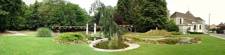 Church Saint-Germain and the Parc du Val-Ombreux


See also
[edit]References
[edit]- Association of Mayors of the Val d'Oise (in French)
- ^ "Répertoire national des élus: les maires" (in French). data.gouv.fr, Plateforme ouverte des données publiques françaises. 13 September 2022.
- ^ "Populations de référence 2022" (in French). The National Institute of Statistics and Economic Studies. 19 December 2024.
- ^ Population en historique depuis 1968, INSEE
External links
[edit]Wikimedia Commons has media related to Soisy-sous-Montmorency.
- Official website (in French)
| International | |
|---|---|
| National | |
| Geographic | |
| Other | |
This Val-d'Oise geographical article is a stub. You can help Wikipedia by expanding it. |
Licensed under CC BY-SA 3.0 | Source: https://en.wikipedia.org/wiki/Soisy-sous-Montmorency11 views | Status: cached on February 21 2025 12:43:21↧ Download as ZWI file
 EncycloReader
is supported by the
EncycloReader
is supported by the