Spokane River
 From Wikipedia - Reading time: 9 min
| Spokane River | |
|---|---|
 Spokane River in Lincoln County, 1909 | |
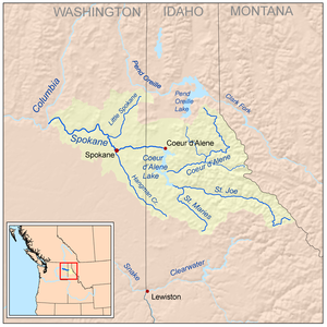
 Spokane River watershed | |
| Etymology | Spokane tribe, the "sun people"[1] |
| Location | |
| Country | United States |
| State | Washington, Idaho |
| County | Kootenai, Spokane, Stevens, Lincoln |
| Physical characteristics | |
| Source | Lake Coeur d'Alene |
| • location | Kootenai County, Idaho |
| • coordinates | 47°40′41″N 117°07′34″W / 47.67806°N 117.12611°W[2] |
| • elevation | 1,994 ft (608 m)[3] |
| Mouth | Columbia River at |
• location | Lake Roosevelt, Washington |
• coordinates | 47°53′38″N 118°20′03″W / 47.89389°N 118.33417°W[2] |
• elevation | 1,293 ft (394 m)[2] |
| Length | 111 mi (179 km)[4] |
| Basin size | 6,020 sq mi (15,600 km2)[5] |
| Discharge | |
| • location | mouth, max and min at Long Lake Dam[5] |
| • average | 7,946 cu ft/s (225.0 m3/s)[5] |
| • minimum | 90 cu ft/s (2.5 m3/s) |
| • maximum | 49,700 cu ft/s (1,410 m3/s) |
| Basin features | |
| Progression | Columbia River → Pacific Ocean |
| River system | Columbia River |
| Tributaries | |
| • left | Cable Creek, Latah Creek, Deep Creek |
| • right | Little Spokane River |
The Spokane River is a tributary of the Columbia River, approximately 111 miles (179 km) long, in northern Idaho and eastern Washington in the United States. It drains a low mountainous area east of the Columbia, passing through the Spokane Valley and the city of Spokane, Washington.
Description
[edit]The Spokane River drains the northern part of Lake Coeur d'Alene in the Idaho Panhandle, emptying into the Columbia River at Franklin D. Roosevelt Lake, approximately 110 miles (180 km) downstream.[6][7]
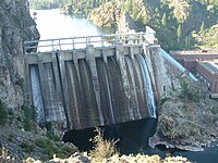
From Lake Coeur d'Alene, the Spokane River traverses the Rathdrum Prairie until reaching Post Falls, Idaho where it passes over a Post Falls Dam, and a natural 40-foot waterfall. Continuing westward it passes over 6 more dams, three of which (Upriver Dam, Upper Falls Dam, Monroe Street Dam) are located in the city of Spokane.[6] In Spokane, it flows over the Spokane Falls, which are located in the heart of Downtown Spokane,[6] approximately one third of the way down the river's length.[8] About a mile later,[citation needed] the river receives Latah Creek from the southeast.[8] Soon afterwards, it is met from the northeast[8] by the Little Spokane River, on the western edge of the city of Spokane.[6] It flows in a zigzag course along the southern edge of the Selkirk Mountains, forming the southern boundary of the Spokane Indian Reservation, where it is impounded by the Long Lake Dam to form Long Lake, a 15-mile (24 km) reservoir. It joins Franklin D. Roosevelt Lake on the Columbia from the east at Miles. The site of historic Fort Spokane is located at the confluence of the Spokane and Columbia rivers.[9]
The Spokane River's entire drainage basin is about 6,240 square miles (16,200 km2) large, of which 3,840 square miles (9,900 km2) are above Post Falls Dam at the outlet of Coeur d'Alene Lake.[10] Its mean annual discharge is 7,946 cubic feet per second (225 m3/s).[5]
Human use
[edit]Until the 18th century, the Coeur d'Alene (Schḭtsu'umsh) and Spokane Native Americans (along with other Salish peoples) used to live and travel along the banks of the Spokane River.[11][12] In 1807, David Thompson was the first European to cross the Rocky Mountains and explore the area.
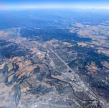
Today, the Spokane metropolitan area (population 573,493) is the largest human settlement on the banks of the Spokane River. The metropolitan area of Coeur d'Alene (pop. 170,628) is immediately to the east and upstream of the Spokane metropolitan area. The Spokane River and Lake Coeur d'Alene are the primary sources of recharge for the Spokane Valley–Rathdrum Prairie Aquifer, which is the primary source of drinking water for each of these settlements.[13]
Pollution
[edit]The Spokane River contains some of the highest concentrations of heavy metals of any river in the state, resulting from pollution coming from Lake Coeur D'Alene and traveling from the Bunker Hill Mine and Smelting Complex Superfund site.[14][15]
Spokane's sewage treatment facilities empty their outflow into the Spokane River. In 1889, Spokane built a sewage system that dumped raw sewage directly into the river, which was visibly noticeable by 1920. In 1957 a primary treatment facility was installed; however, this was soon deemed inadequate by the Washington State Department of Ecology. This led to the construction of a more advanced treatment plant that utilized chemical precipitation technology, which was connected in 1975, and operational by 1977.[16]
Fish habitat
[edit]
After the Northern Pacific Railway lines arrived in Spokane in 1882, there was rapid growth in milling operations along the river. Many of these mills required dams to provide power for their machinery. As a result of the dams blocking the river, salmon populations in the Spokane plummeted, leading to complaints from many of the people living upstream.[17] After the construction of Little Falls Dam in 1910 by Washington Water Power blocked upstream passage, the river's salmon populations disappeared completely.[18]
Steelhead were also abundant on the Spokane River, prior to pollution and the construction of the dams. Today, the Spokane River system is one of the two largest unoccupied stretches of steelhead habitat within their former range.[19]
Today, the Spokane River supports populations of rainbow trout, northern pikeminnow, and Bridgelip Suckers (Catostomus columbianus), as well as several non-native species.[18] Many of the remaining fish, however, are not suitable for human consumption due to the chemical pollution in the river, with signs alongside the river warning that the fish are contaminated with PCBs.[20]
Crossings
[edit]
See also
[edit]- Bunker Hill Mine and Smelting Complex
- List of Idaho rivers
- List of longest streams of Idaho
- List of Washington rivers
- Spokane River Centennial Trail
- North Idaho Centennial Trail
- Harker Canyon
References
[edit]- ^ Phillips, James W. (1971). Washington State Place Names. University of Washington Press. pp. 134–135. ISBN 0-295-95498-1.
- ^ a b c "Spokane River". Geographic Names Information System (GNIS). United States Geological Survey (USGS). September 10, 1979. Retrieved October 17, 2008.
- ^ Source elevation derived from Google Earthsearch using GNIS source coordinates.
- ^ "Online Topographic Maps from the United States Geological Survey". TopoQuest. Retrieved October 19, 2008.
- ^ a b c d Benke, Arthur C. & Cushing, Colbert E. (2005). Rivers of North America. Academic Press. p. 650. ISBN 978-0-12-088253-3. Retrieved 2008-10-16.
- ^ a b c d National Research Council, 2005: p. 92
- ^ Soltero et al., 1994: p. 460
- ^ a b c Ruby, Robert H. & Brown, John A. (2006). The Spokane Indians: Children of the Sun. University of Oklahoma Press. p. 8. ISBN 978-0-8061-3761-2.
- ^ National Park Service. Fort Spokane
- ^ Spokane Subbasin Plan Archived 2011-07-25 at the Wayback Machine, Northwest Power and Conservation Council; and Intermountain Subbasin Plan, Coeur d'Alene Archived 2011-09-27 at the Wayback Machine, Northwest Power and Conservation Council
- ^ Pritzker, Barry, ed. (2000). A Native American encyclopedia: history, culture, and peoples. Oxford University Press. p. 254. ISBN 978-0-19-513897-9.
- ^ Frey, Rodney in collaboration with the Schḭtsu'umsh (2001). Landscape Traveled by Coyote and Crane: The World of the Schḭtsu'umsh (Coeur d'Alene Indians). University of Washington Press. p. 17. ISBN 0-295-98162-8.
- ^ National Research Council, 2005: p. 93
- ^ Lindholdt, Paul J. (2011). In Earshot of Water: Notes from the Columbia Plateau. University of Iowa Press. p. 111. ISBN 978-1-58729-984-1.
- ^ Rosen, J.F., Science of the Total Environment, Volume: 303 Issue: 1-2, Pages: 15–23, Published: February 15, 2003
- ^ Edmondson, W.T. (1996). The Uses of Ecology: Lake Washington and Beyond. University of Washington Press. p. 204. ISBN 978-0-295-97569-6.
- ^ Taylor, Joseph E. (2001). Making Salmon: An Environmental History of the Northwest Fisheries Crisis. University of Washington Press. p. 54. ISBN 978-0-295-98114-7.
- ^ a b Fahey, John (1991); "Power Plays: The Enigma of Little Falls," Pacific Northwest Quarterly 82, no.4 (October 1991), 122–131.
- ^ Thurow, Russell F.; et al. (2000). "Status and Distribution of Chinook Salmon and Steelhead in the Interior Columbia River Basin and Portions of the Klamath River Basin". In Knudsen, E. Eric (ed.). Sustainable fisheries management: Pacific salmon. CRC Press. p. 143. ISBN 978-1-56670-480-9.
- ^ Jensen, Derrick (2004). A Language Older Than Words. Chelsea Green Publishing. p. 279. ISBN 978-1-931498-55-5.
Bibliography
[edit]- National Research Council Committee on Superfund Site Assessment (2005). Superfund and mining megasites: lessons from the Coeur D'Alene River basin. National Academies Press. ISBN 978-0-309-09714-7.
- Soltero, Raymond A.; et al. (1994). "The Changing Spokane River Watershed". In Naiman, Robert J. (ed.). Watershed Management: Balancing Sustainability and Environmental Change. Springer. pp. 458–478. ISBN 978-0-387-94232-2.
Further reading
[edit]- Clark, Ella E. & Inverarity, Robert Bruce (2003). "The Origin of the Spokane River". Indian Legends of the Pacific Northwest. University of California Press. pp. 116–117. ISBN 978-0-520-23926-5.
 KSF
KSF