Staré
 From Wikipedia - Reading time: 7 min
Staré
Sztára | |
|---|---|
 | |
 Flag | |
 Staré Location of Staré in the Košice Region  Staré Location of Staré in Slovakia | |
| Coordinates: 48°52′N 21°52′E / 48.87°N 21.87°E | |
| Country | |
| Region | |
| District | Michalovce District |
| First mentioned | 1273 |
| Area | |
• Total | 18.02 km2 (6.96 sq mi) |
| Elevation | 147 m (482 ft) |
| Population (2021)[3] | |
• Total | 761 |
| Time zone | UTC+1 (CET) |
| • Summer (DST) | UTC+2 (CEST) |
| Postal code | 722 3[2] |
| Area code | +421 56[2] |
| Car plate | MI |
| Website | www |
Staré (Hungarian: Sztára) is a village and municipality in Michalovce District in the Kosice Region of eastern Slovakia.
History
[edit]In historical records the village was first mentioned in 1221.
Geography
[edit]The village lies at an altitude of 107 metres and covers an area of 6.234 km2. The municipality has a population of about 700 people. The name was taken from gróf Sztáray. [4]
Gallery
[edit]-
 Church of the Assumption of the Virgin Mary, est. 1842 (July 2006)
 -
 Statue of John of Nepomuk in Staré
 -
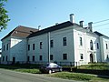 Manor house in Staré, est. early 1600s (July 2006)
 -
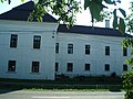 Manor house in Staré, est. early 1600s (July 2006)
 -
 Manor house in Staré, est. early 1600s (July 2006)
 -
 Village granary in Neo-Classical style, est. 1804 (July 2006)
 -
 Village granary in Neo-Classical style, est. 1804 (July 2006)
 -
 Village granary in Neo-Classical style, est. 1804 (July 2006)
_church_(summer)_02.jpg)
_statue_of_St_John_of_Nepomuk_(summer).jpg)
_manor_house_(summer)_05.jpg)
_manor_house_(summer)_03.jpg)
_manor_house_(summer)_01.jpg)
_village_granary_(est._1804,_summer)_01.jpg)
_village_granary_(est._1804,_summer)_03.jpg)
_village_granary_(est._1804,_summer)_02.jpg)
References
[edit]- ^ "Hustota obyvateľstva - obce [om7014rr_ukaz: Rozloha (Štvorcový meter)]". www.statistics.sk (in Slovak). Statistical Office of the Slovak Republic. 2022-03-31. Retrieved 2022-03-31.
- ^ a b c "Základná charakteristika". www.statistics.sk (in Slovak). Statistical Office of the Slovak Republic. 2015-04-17. Retrieved 2022-03-31.
- ^ "Počet obyvateľov podľa pohlavia - obce (ročne)". www.statistics.sk (in Slovak). Statistical Office of the Slovak Republic. 2022-03-31. Retrieved 2022-03-31.
- ^ "Obec Staré". Archived from the original on 2010-02-14.
This Michalovce District geography article is a stub. You can help Wikipedia by expanding it. |
Licensed under CC BY-SA 3.0 | Source: https://en.wikipedia.org/wiki/Staré25 views | Status: cached on July 03 2025 00:16:17↧ Download as ZWI file
 EncycloReader
is supported by the
EncycloReader
is supported by the