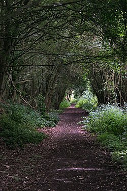
The Railway Walks
 From Wikipedia - Reading time: 5 min
| The Railway Walks | |
|---|---|
 | |
 | |
| Type | Local Nature Reserve |
| Location | Sudbury to Lavenham, Suffolk |
| OS grid | TL 9043 4923 |
| Coordinates | 52°06′31″N 0°46′46″E / 52.108611°N 0.779403°E |
| Area | 25.3 hectares |
| Managed by | Suffolk County Council |
The Railway Walks is a 25.3 hectare Local Nature Reserve which runs along parts of a former railway line between Sudbury and Lavenham in Suffolk. It is owned and managed by Suffolk County Council.[1][2]
The walk has diverse fauna and flora in habitats such as water meadows, streams, ditches and ponds.[1] Birds include willow warblers, kingfishers, woodpeckers, mallards, moorhens and swans.[3]
Wikimedia Commons has media related to The Railway Walks.
References
[edit]- ^ a b "The Railway Walks". Local Nature Reserves. Natural England. 28 March 2013. Retrieved 1 August 2017.
- ^ "Map of The Railway Walks". Local Nature Reserves. Natural England. Retrieved 1 August 2017.
- ^ Falk, David (23 May 2011). "Walk: Sudbury's Valley Trail". East Anglian Times. Retrieved 1 August 2017.
Licensed under CC BY-SA 3.0 | Source: https://en.wikipedia.org/wiki/The_Railway_Walks25 views | Status: cached on April 12 2025 07:20:16↧ Download as ZWI file
 KSF
KSF