Toad Hop, Indiana
 From Wikipedia - Reading time: 6 min
Toad Hop, Indiana | |
|---|---|
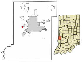
 Location of Toad Hop in Vigo County, Indiana. | |
| Coordinates: 39°27′32″N 87°27′49″W / 39.45889°N 87.46361°W | |
| Country | United States |
| State | Indiana |
| County | Vigo |
| Township | Sugar Creek |
| Area | |
• Total | 0.21 sq mi (0.55 km2) |
| • Land | 0.21 sq mi (0.55 km2) |
| • Water | 0.00 sq mi (0.00 km2) |
| Elevation | 469 ft (143 m) |
| Population (2020) | |
• Total | 104 |
| • Density | 490.57/sq mi (189.46/km2) |
| Time zone | UTC-5 (Eastern (EST)) |
| • Summer (DST) | UTC-4 (EDT) |
| ZIP code | 47885 |
| Area code(s) | 812, 930 |
| GNIS feature ID | 444789 |
Toad Hop is an unincorporated census-designated place in Sugar Creek Township, Vigo County, in the U.S. state of Indiana.[3] It is officially part of West Terre Haute. In 2010, Toad Hop was a census designated place.[4] It is part of the Terre Haute metropolitan area.
Name origin
[edit]The origin of the name Toad Hop is deeply rooted in legend. One explanation is that the town was laid out on a swampy field, and the abundance of toads and frogs hopping around inspired the name.[5]
Geography
[edit]Toad Hop is located at 39°27′32″N 87°27′49″W / 39.45889°N 87.46361°W at an elevation of 476 feet. This is the mostly wooded area between the I-70 exit (Darwin Road) and US 40.
Demographics
[edit]| Census | Pop. | Note | %± |
|---|---|---|---|
| 2010 | 108 | — | |
| 2020 | 104 | −3.7% | |
| U.S. Decennial Census[6] | |||
As of the 2010 Census, 108 people lived in Toad Hop. 107 residents were White and 1 was of two or more races. The median age was 40 years old.[7]
References
[edit]- ^ "2020 U.S. Gazetteer Files". United States Census Bureau. Retrieved March 16, 2022.
- ^ "US Board on Geographic Names". United States Geological Survey. October 25, 2007. Retrieved July 13, 2016.
- ^ "Toad Hop, Indiana". Geographic Names Information System. United States Geological Survey, United States Department of the Interior. Retrieved June 24, 2010.
- ^ "Toad Hop Census Designated Place". Geographic Names Information System. United States Geological Survey, United States Department of the Interior. Retrieved June 24, 2010.
- ^ Baker, Ronald L. (October 1995). From Needmore to Prosperity: Hoosier Place Names in Folklore and History. Indiana University Press. p. 325. ISBN 978-0-253-32866-3.
...toads hopping and frogs jumping, and hence the name Toad Hop.
- ^ "Census of Population and Housing". Census.gov. Retrieved June 4, 2016.
- ^ "U.S. Census website". census.gov. United States Census Bureau. Retrieved January 26, 2020.
 KSF
KSF