Troy Hills, New Jersey
 From Wikipedia - Reading time: 8 min
Troy Hills, New Jersey | |
|---|---|
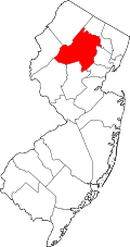
Location in Morris County Location in New Jersey | |
| Coordinates: 40°51′9″N 74°23′32″W / 40.85250°N 74.39222°W | |
| Country | |
| State | |
| County | Morris |
| Township | Parsippany–Troy Hills |
| Area | |
• Total | 2.92 sq mi (7.55 km2) |
| • Land | 2.88 sq mi (7.45 km2) |
| • Water | 0.04 sq mi (0.10 km2) |
| Elevation | 225 ft (69 m) |
| Population | |
• Total | 5,081 |
| • Density | 1,765.46/sq mi (681.58/km2) |
| Time zone | UTC−05:00 (Eastern (EST)) |
| • Summer (DST) | UTC−04:00 (EDT) |
| ZIP Code | 07054 (Parsippany) |
| Area code(s) | 973/862 |
| FIPS code | 34-74150[3] |
| GNIS feature ID | 2806209[4] |
Troy Hills is a census-designated place (CDP)[5] in the township of Parsippany–Troy Hills, Morris County, New Jersey, United States. As of the 2020 census, it had a population of 5,081.[2]
Geography
[edit]Troy Hills is in eastern Morris County, in the southeast part of Parsippany–Troy Hills Township. It is bordered to the north and west by the Parsippany CDP, to the south by Whippany in Hanover Township, and to the east by Troy Meadows, the largest freshwater marsh in New Jersey.
Interstate 80 forms the northern edge of the CDP, and Jefferson Road is the western edge. Troy Hills is 6 miles (10 km) northeast of Morristown and 17 miles (27 km) northwest of Newark.
According to the U.S. Census Bureau, the Troy Hills CDP has a total area of 2.92 square miles (7.56 km2), of which 2.88 square miles (7.46 km2) are land and 0.04 square miles (0.10 km2), or 1.27%, are water.[1] The community is drained by Troy Brook, which flows east into Troy Meadows and is a tributary of the Whippany River, part of the Passaic River watershed.
Demographics
[edit]| Census | Pop. | Note | %± |
|---|---|---|---|
| 2020 | 5,081 | — | |
| U.S. Decennial Census[6][2] | |||
Troy Hills first appeared as a census designated place in the 2020 U.S. Census.[7]
References
[edit]- ^ a b "2024 U.S. Gazetteer Files: New Jersey". United States Census Bureau. Retrieved November 8, 2024.
- ^ a b c "Census Population API". United States Census Bureau. Retrieved October 11, 2022.
- ^ Geographic Codes Lookup for New Jersey, Missouri Census Data Center. Accessed June 9, 2023.
- ^ "Troy Hills Census Designated Place". Geographic Names Information System. United States Geological Survey, United States Department of the Interior.
- ^ State of New Jersey Census Designated Places - BVP20 - Data as of January 1, 2020, United States Census Bureau. Accessed December 1, 2022.
- ^ "Census of Population and Housing". Census.gov. Retrieved June 4, 2016.
- ^ "2020 Geography Changes". United States Census Bureau.
 KSF
KSF


