Tuningen
 From Wikipedia - Reading time: 7 min
You can help expand this article with text translated from the corresponding article in German. (February 2009) Click [show] for important translation instructions.
|
Tuningen | |
|---|---|
 Coat of arms | |
Location of Tuningen within Schwarzwald-Baar-Kreis district 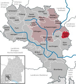 | |
 Tuningen  Tuningen | |
| Coordinates: 48°01′36″N 8°36′07″E / 48.0268°N 08.6019°E | |
| Country | Germany |
| State | Baden-Württemberg |
| Admin. region | Freiburg |
| District | Schwarzwald-Baar-Kreis |
| Municipal assoc. | Villingen-Schwenningen |
| Government | |
| • Mayor (2019–27) | Ralf Pahlow[1] |
| Area | |
• Total | 15.59 km2 (6.02 sq mi) |
| Elevation | 743 m (2,438 ft) |
| Population (2023-12-31)[2] | |
• Total | 3,142 |
| • Density | 200/km2 (520/sq mi) |
| Time zone | UTC+01:00 (CET) |
| • Summer (DST) | UTC+02:00 (CEST) |
| Postal codes | 78609 |
| Dialling codes | 07464 |
| Vehicle registration | VS |
| Website | www.tuningen.de |
Tuningen is a Gemeinde (municipality) located in the Schwarzwald-Baar district in the middle of Baden-Württemberg, Germany.
The municipality belongs to the administrative authority (Verwaltungsgemeinschaft) of Villingen-Schwenningen.
Geography
[edit]Tuningen is located at the east border of the Black Forest about 14 km south-east of the district town Villingen-Schwenningen, 6 km east of Bad Dürrheim and 5 km south-west of Trossingen.
History
[edit]The first explicit reference to Tuningen dates to 797, in a deed of donation by the cloister St. Gallen.
Twin towns
[edit] Camogli, Italy, since 1998
References
[edit]- ^ Aktuelle Wahlergebnisse, Staatsanzeiger, accessed 14 September 2021.
- ^ "Bevölkerung nach Nationalität und Geschlecht am 31. Dezember 2023 (Fortschreibung auf Basis des Zensus 2022)" [Population by nationality and sex as of December 31, 2023 (updated based on the 2022 census)] (CSV) (in German). Statistisches Landesamt Baden-Württemberg.
External links
[edit]
| International | |
|---|---|
| National | |
| Geographic | |
This Schwarzwald-Baar location article is a stub. You can help Wikipedia by expanding it. |
Licensed under CC BY-SA 3.0 | Source: https://en.wikipedia.org/wiki/Tuningen54 views | Status: cached on August 04 2025 15:15:58↧ Download as ZWI file
 EncycloReader
is supported by the
EncycloReader
is supported by the