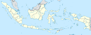
Upaga
 From Wikipedia - Reading time: 6 min
Upaga | |
|---|---|
| Coordinates: 4°1′10.9974″S 137°42′37.90512″E / 4.019721500°S 137.7105292000°E | |
| Country | |
| Province | Central Papua |
| Regency | Puncak Regency |
| Elevation | 11,910 ft (3,630 m) |
| Population (2010) | |
• Total | 2,289 |
| Time zone | UTC+9 (Indonesia Eastern Standard Time) |
Upaga is a village in Puncak Regency, Central Papua province, Indonesia. It is located at around 4°1′10.9974″S 137°42′37.90512″E / 4.019721500°S 137.7105292000°E, in the elevation of around 3,630 metres.[1] Its population is 2,289[2]: 2141
Climate
[edit]Although Upaga is located on tropical latitudes, the very high elevation causes its Climate to be classified as Subpolar oceanic (Cfc) with cold temperatures and very heavy rainfall year-round.
| Climate data for Upaga | |||||||||||||
|---|---|---|---|---|---|---|---|---|---|---|---|---|---|
| Month | Jan | Feb | Mar | Apr | May | Jun | Jul | Aug | Sep | Oct | Nov | Dec | Year |
| Mean daily maximum °C (°F) | 16 (61) |
15.9 (60.6) |
15.4 (59.7) |
14.7 (58.5) |
13.8 (56.8) |
12.7 (54.9) |
11.8 (53.2) |
11.8 (53.2) |
13.1 (55.6) |
15 (59) |
15.7 (60.3) |
16 (61) |
14.3 (57.8) |
| Daily mean °C (°F) | 10.0 (50.0) |
10.0 (50.0) |
10.0 (50.0) |
9.5 (49.1) |
9.1 (48.4) |
8.4 (47.1) |
7.8 (46.0) |
7.6 (45.7) |
8.1 (46.6) |
9.2 (48.6) |
9.5 (49.1) |
10.1 (50.2) |
9.1 (48.4) |
| Mean daily minimum °C (°F) | 4.1 (39.4) |
4.2 (39.6) |
4.6 (40.3) |
4.4 (39.9) |
4.4 (39.9) |
4.1 (39.4) |
3.8 (38.8) |
3.4 (38.1) |
3.2 (37.8) |
3.5 (38.3) |
3.4 (38.1) |
4.2 (39.6) |
3.9 (39.1) |
| Average precipitation mm (inches) | 305 (12.0) |
343 (13.5) |
304 (12.0) |
296 (11.7) |
297 (11.7) |
298 (11.7) |
303 (11.9) |
285 (11.2) |
279 (11.0) |
290 (11.4) |
271 (10.7) |
293 (11.5) |
3,564 (140.3) |
| Source: Climate-Data.org[3] | |||||||||||||
References
[edit]- ^ "Elevation Finder". www.freemaptools.com. Archived from the original on 2020-05-16. Retrieved 2019-09-15.
- ^ "Archived copy" (PDF). Archived from the original (PDF) on 2013-07-31. Retrieved 2020-01-02.
{{cite web}}: CS1 maint: archived copy as title (link) - ^ "Climate: Upaga". Climate-Data.org. Retrieved September 15, 2019.
Licensed under CC BY-SA 3.0 | Source: https://en.wikipedia.org/wiki/Upaga7 views | Status: cached on March 30 2025 16:22:47↧ Download as ZWI file
 KSF
KSF
