Urisino
 From Wikipedia - Reading time: 6 min
Urisino Station, most commonly known as Urisino, is a pastoral lease that has operated as both a sheep station and a cattle station in outback New South Wales.
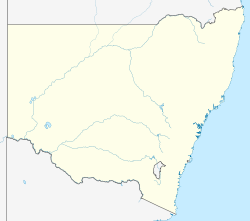
It is situated about 140 kilometres (87 mi) north east of White Cliffs and 200 kilometres (124 mi) west of Bourke. The vegetation is predominantly composed of mulga and mixed native species including bimble box. In 2014 the area had found to have been overgrazed by sheep and feral goats.[1]
History
[edit]Urisino was owned by Samuel Wilson in the 1860s.[2] By 1883 the owners had spent £28,800 on improvements.[3] In 1894 approximately 120,000 sheep were being shorn at Urisino.[4]
In 1913 the property was running sheep and was being managed by Mr Tooth who was also the manager of Elsinora and Thurloo Downs Stations.[5]
Ursino was later a strategic watering hole for stock belonging to Sidney Kidman.[2] Kidman acquired the property in 1918[6] along with Elsinora and Thurloo Downs from Goldsbrough Mort & Co.[7] and held it until 1923.[2]
The property occupied an area of 81,200 acres (32,860 ha) in 1935 and received an average rainfall of 9 inches (229 mm).[8]
The station was abandoned and in disrepair in 1992 when it was acquired by Andrea Rudd and Paul Hansen. The pair restored the homestead making it suitable tourist accommodation.[9]
Since 2007 the station has been the focus of the largest carbon project in Australia's history; the Urisino Forest Regeneration Project.[10] The project works to de-stock the overgrazing feral animals in a humane way, allowing the flora and fauna to recover from the previous drought-stricken state. It is recognised under the Australian Carbon Farming Initiative.[11]
See also
[edit]References
[edit]- ^ "Australian Farm Abatement Registry – Details for Urisino". Australian Carbon traders. Archived from the original on 20 March 2012. Retrieved 20 September 2015.
- ^ a b c "Urisino Bush Xanadu, a cultural oasis, a unique cultural icon". Carbon Heritage. Archived from the original on 30 May 2010. Retrieved 20 September 2015.
- ^ "Western Improvements". The Riverine Grazier. Hay, New South Wales: National Library of Australia. 26 December 1883. p. 4. Retrieved 23 September 2015.
- ^ "The Pastoralists and shearers. The new shearing agreement". The Sydney Morning Herald. Sydney, New South Wales: National Library of Australia. 26 June 1894. p. 3. Retrieved 10 October 2015.
- ^ "Afghan Carriers in Bourke District". The Cobar Herald. Cobar, New South Wales: National Library of Australia. 31 October 1913. p. 6. Retrieved 20 September 2015.
- ^ "Pastoralism - Unincorporated Area of New South Wales Heritage Study" (PDF). OutbackNSW.com.au. River Junction Research. 2006. Archived from the original (PDF) on 4 May 2013. Retrieved 20 September 2015.
- ^ "Wanaaring Whispers". Western Herald. Bourke, New South Wales: National Library of Australia. 27 July 1918. p. 2. Retrieved 21 September 2015.
- ^ "Wanaaring Lands for make-ups". Western Herald. Bourke, New South Wales: National Library of Australia. 27 December 1935. p. 7. Retrieved 20 September 2015.
- ^ "Life anew for old Urisino". National Library of Australia. 1 April 1997. Archived from the original on 9 April 2017. Retrieved 20 September 2015.
- ^ "Urisino forest regeneration". Climate Friendly. Archived from the original on 23 March 2016. Retrieved 16 March 2016.
- ^ "Urisino". urisino.com. Archived from the original on 21 March 2016. Retrieved 16 March 2016.
 KSF
KSF