Valverde (Madrid)
 From Wikipedia - Reading time: 6 min
Valverde | |
|---|---|
 | |
 | |
| Country | Spain |
| Region | Community of Madrid |
| Municipality | Madrid |
| District | Fuencarral-El Pardo |
| Area | |
• Total | 8.977802 km2 (3.466349 sq mi) |
| Population (2020) | |
• Total | 65,022 |
| • Density | 7,200/km2 (19,000/sq mi) |
 | |
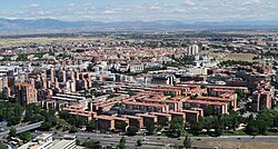
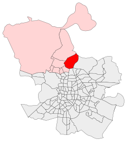
Valverde is an administrative neighborhood (barrio) of Madrid belonging to the district of Fuencarral-El Pardo. It has an area of 8.977802 km2 (3.466349 sq mi).[1] As of 1 March 2020, it has a population of 65,022.[2] The historic centre of Fuencarral (Fuencarral Pueblo), belongs to the Valverde neighborhood.[3] The Hospital Universitario Ramón y Cajal is also located in the neighborhood.
References
[edit]- ^ "Callejero vigente. Barrios". Ayuntamiento de Madrid.
- ^ "Población por distrito y barrio". Ayuntamiento de Madrid. Retrieved 20 March 2020.
- ^ "Los nombres no oficiales de los barrios del norte de Madrid". temploconsulting.com. 12 June 2018.
Wikimedia Commons has media related to Valverde neighborhood, Madrid.
Licensed under CC BY-SA 3.0 | Source: https://en.wikipedia.org/wiki/Valverde_(Madrid)15 views | Status: cached on March 15 2025 23:34:14↧ Download as ZWI file
 KSF
KSF