Washington Township, Morgan County, Indiana
 From Wikipedia - Reading time: 6 min
Washington Township | |
|---|---|
 Intersection of State Highways 37 and 252 in Washington Township | |
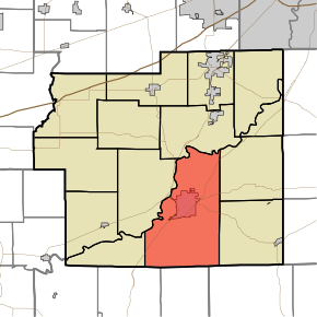
 Location in Morgan County | |
| Coordinates: 39°24′22″N 86°24′54″W / 39.40611°N 86.41500°W | |
| Country | |
| State | |
| County | Morgan |
| Government | |
| • Type | Indiana township |
| Area | |
• Total | 59.03 sq mi (152.9 km2) |
| • Land | 57.51 sq mi (149.0 km2) |
| • Water | 1.51 sq mi (3.9 km2) 2.56% |
| Elevation | 604 ft (184 m) |
| Population | |
• Total | 17,657 |
| • Density | 296.9/sq mi (114.6/km2) |
| Time zone | UTC-5 (Eastern (EST)) |
| • Summer (DST) | UTC-4 (EDT) |
| ZIP codes | 46151, 46160 |
| GNIS feature ID | 454008 |
Washington Township is one of fourteen townships in Morgan County, Indiana, United States. As of the 2010 census, its population was 17,073 and it contained 7,171 housing units.[2] The township contains a portion of the Morgan–Monroe State Forest.
History
[edit]The Cross School, Grassyfork Fisheries Farm No. 1, and Long Schoolhouse are listed on the National Register of Historic Places.[3][4]
Geography
[edit]According to the 2010 census, the township has a total area of 59.03 square miles (152.9 km2), of which 57.51 square miles (149.0 km2) (or 97.43%) is land and 1.51 square miles (3.9 km2) (or 2.56%) is water.[2] The White River defines the township's north border.
Cities, towns, villages
[edit]Unincorporated towns
[edit]- Champlin Meadows at 39°24′27″N 86°26′12″W / 39.407547°N 86.436662°W
- Mahalasville at 39°21′37″N 86°21′46″W / 39.360326°N 86.362771°W
- Maxwell at 39°23′14″N 86°27′20″W / 39.38727°N 86.455551°W
- Shelburne at 39°26′07″N 86°23′34″W / 39.435325°N 86.392772°W
- Stines Mill Corner at 39°28′33″N 86°22′22″W / 39.475881°N 86.372771°W
- Willowbrook Estates at 39°28′39″N 86°21′54″W / 39.477548°N 86.364993°W [5]
- Wolff at 39°25′59″N 86°23′43″W / 39.433103°N 86.395272°W
- Woodcrest at 39°26′15″N 86°23′41″W / 39.437548°N 86.394716°W
(This list is based on USGS data and may include former settlements.)
Cemeteries
[edit]The township contains these four cemeteries: Hill Dale, Maxwell, Nutter and Williams.
Major highways
[edit]- Interstate 69
 Indiana State Road 37
 Indiana State Road 39
 Indiana State Road 44
 Indiana State Road 67
 Indiana State Road 252
Airports and landing strips
[edit]- McDaniels Field
Lakes
[edit]- Spring Lake
School districts
[edit]- Metropolitan School District of Martinsville Schools
Political districts
[edit]- Indiana's 4th congressional district
- State House District 47
- State Senate District 37
References
[edit]- "Washington Township, Morgan County, Indiana". Geographic Names Information System. United States Geological Survey, United States Department of the Interior. Retrieved September 26, 2009.
- United States Census Bureau 2008 TIGER/Line Shapefiles
- IndianaMap
- ^ "Census Bureau profile: Washington Township, Morgan County, Indiana". United States Census Bureau. May 2023. Retrieved March 24, 2024.
- ^ a b "Population, Housing Units, Area, and Density: 2010 - County -- County Subdivision and Place -- 2010 Census Summary File 1". United States Census. Archived from the original on February 12, 2020. Retrieved May 10, 2013.
- ^ "National Register Information System". National Register of Historic Places. National Park Service. July 9, 2010.
- ^ "National Register of Historic Places Listings". Weekly List of Actions Taken on Properties: 7/09/12 through 7/13/12. National Park Service. July 20, 2012.
- ^ "Willowbrook Estates, Indiana". Geographic Names Information System. United States Geological Survey, United States Department of the Interior. Retrieved June 4, 2017.
 KSF
KSF