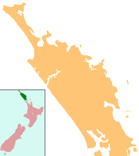
Whangarei Harbour Marine Reserve
 From Wikipedia - Reading time: 3 min
| Whangarei Harbour Marine Reserve | |
|---|---|
| Location | New Zealand |
| Coordinates | 35°48′03″S 174°25′00″E / 35.800829°S 174.416628°E |
| Area | 236.51 ha (584.4 acres) |
| Established | 2006 |
| Governing body | Department of Conservation |
The Whangarei Harbour Marine Reserve is a protected area in the North Island of New Zealand. It was established in 2006 and measures 236.5 ha (584 acres)[1] over two sites.[2] The students and faculty of the nearby Kamo High School played an important role in establishing this reserve.[3][4]
The reserve is governed by the Marine Reserves Act 1971 and is administered by the Department of Conservation.[5] It was announced at an event held at Kamo High School in 2006 by the then Minister of Conservation, the Hon Chris Carter.
See also
[edit]References
[edit]- ^ "Data Table - Protected Areas - LINZ Data Service (recorded area 236.51 ha)". Land Information New Zealand. Retrieved 29 August 2019.
- ^ "Whangarei Harbour Marine Reserve". Department of Conservation. 26 November 2013. Retrieved 24 April 2010.
- ^ Warne, Kennedy. "Blue Haven: New Zealand marine reserves are a model for the world." National Geographic Magazine: April 2007. [1]
- ^ Lynch, Brigid (19 October 2006). "Marine reserve created by young enthusiasm". The New Zealand Herald. Retrieved 3 December 2011.
- ^ "Marine Reserve (Whangarei Harbour) Order 2006 (SR 2006/283)". NZ Government. 11 September 2006. Retrieved 24 April 2010.
External links
[edit]Licensed under CC BY-SA 3.0 | Source: https://en.wikipedia.org/wiki/Whangarei_Harbour_Marine_Reserve18 views | Status: cached on February 16 2025 18:17:06↧ Download as ZWI file
 KSF
KSF