Categories
  Encyclosphere.org ENCYCLOREADER
  supported by EncyclosphereKSF

White County, New South Wales

From Wikipedia - Reading time: 5 min

White
New South Wales
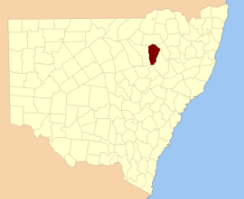
Location in New South Wales
Lands administrative divisions around White:
Jamison Jamison Nandewar
Baradine White Pottinger
Gowen Napier Pottinger

White County is one of the 141 cadastral divisions of New South Wales. It is located to the south of the Namoi River along both sides of Bohena Creek, with Narrabri at the northern end. It includes most of the Pilliga Nature Reserve.

White County was named in honour of the surveyor and diarist George Boyle White (1802-1876).[1]

Parishes within this county

[edit]

A full list of parishes found within this county; their current LGA and mapping coordinates to the approximate centre of each location is as follows:

Parish LGA Coordinates
Arrarownie Narrabri Shire 30°44′54″S 149°20′04″E / 30.74833°S 149.33444°E / -30.74833; 149.33444 (Arrarownie)
Belmore Narrabri Shire 30°24′54″S 149°18′04″E / 30.41500°S 149.30111°E / -30.41500; 149.30111 (Belmore)
Blake Narrabri Shire 30°26′54″S 149°43′04″E / 30.44833°S 149.71778°E / -30.44833; 149.71778 (Blake)
Bohena Narrabri Shire 30°25′54″S 149°37′04″E / 30.43167°S 149.61778°E / -30.43167; 149.61778 (Bohena)
Borah Warrumbungle Shire 31°05′54″S 149°36′04″E / 31.09833°S 149.60111°E / -31.09833; 149.60111 (Borah)
Boral Narrabri Shire 30°20′54″S 149°38′04″E / 30.34833°S 149.63444°E / -30.34833; 149.63444 (Boral)
Brigalow Narrabri Shire 30°31′54″S 149°42′04″E / 30.53167°S 149.70111°E / -30.53167; 149.70111 (Brigalow)
Bulgarra Narrabri Shire 30°19′54″S 149°15′04″E / 30.33167°S 149.25111°E / -30.33167; 149.25111 (Bulgarra)
Capp Narrabri Shire 30°25′54″S 149°24′04″E / 30.43167°S 149.40111°E / -30.43167; 149.40111 (Capp)
Cocaboy Narrabri Shire 30°46′54″S 149°33′04″E / 30.78167°S 149.55111°E / -30.78167; 149.55111 (Cocaboy)
Coghill Narrabri Shire 30°31′54″S 149°17′04″E / 30.53167°S 149.28444°E / -30.53167; 149.28444 (Coghill)
Cook Narrabri Shire 30°32′54″S 149°22′04″E / 30.54833°S 149.36778°E / -30.54833; 149.36778 (Cook)
Cooma Narrabri Shire 30°20′54″S 149°43′04″E / 30.34833°S 149.71778°E / -30.34833; 149.71778 (Cooma)
Coormore Warrumbungle Shire 30°54′54″S 149°21′04″E / 30.91500°S 149.35111°E / -30.91500; 149.35111 (Coormore)
Cowallah Narrabri Shire 30°40′54″S 149°36′04″E / 30.68167°S 149.60111°E / -30.68167; 149.60111 (Cowallah)
Cox Warrumbungle Shire 31°00′54″S 149°35′04″E / 31.01500°S 149.58444°E / -31.01500; 149.58444 (Cox)
Crowie Narrabri Shire 30°29′54″S 149°35′04″E / 30.49833°S 149.58444°E / -30.49833; 149.58444 (Crowie)
Dampier Narrabri Shire 30°29′54″S 149°30′04″E / 30.49833°S 149.50111°E / -30.49833; 149.50111 (Dampier)
Dangar Narrabri Shire 30°44′54″S 149°30′04″E / 30.74833°S 149.50111°E / -30.74833; 149.50111 (Dangar)
Denobollie Narrabri Shire 30°48′54″S 149°19′04″E / 30.81500°S 149.31778°E / -30.81500; 149.31778 (Denobollie)
Dewhurst Narrabri Shire 30°46′54″S 149°42′04″E / 30.78167°S 149.70111°E / -30.78167; 149.70111 (Dewhurst)
Galloway Narrabri Shire 30°45′54″S 149°35′04″E / 30.76500°S 149.58444°E / -30.76500; 149.58444 (Galloway)
Goona Narrabri Shire 30°35′54″S 149°35′04″E / 30.59833°S 149.58444°E / -30.59833; 149.58444 (Goona)
Gorman Narrabri Shire 30°31′54″S 149°50′04″E / 30.53167°S 149.83444°E / -30.53167; 149.83444 (Gorman)
Gurleigh Narrabri Shire 30°14′54″S 149°32′04″E / 30.24833°S 149.53444°E / -30.24833; 149.53444 (Gurleigh)
Humphrey Warrumbungle Shire 30°57′54″S 149°26′04″E / 30.96500°S 149.43444°E / -30.96500; 149.43444 (Humphrey)
Iredale Warrumbungle Shire 30°53′54″S 149°35′04″E / 30.89833°S 149.58444°E / -30.89833; 149.58444 (Iredale)
Lloyd Narrabri Shire 30°52′54″S 148°26′04″E / 30.88167°S 148.43444°E / -30.88167; 148.43444 (Lloyd)
Loder Narrabri Shire 30°19′54″S 149°21′04″E / 30.33167°S 149.35111°E / -30.33167; 149.35111 (Loder)
Loftus Warrumbungle Shire 30°54′54″S 149°30′04″E / 30.91500°S 149.50111°E / -30.91500; 149.50111 (Loftus)
Mallallee Narrabri Shire 30°47′54″S 149°30′04″E / 30.79833°S 149.50111°E / -30.79833; 149.50111 (Mallallee)
Mallee Unincorporated 34°53′14″S 143°24′54″E / 34.88722°S 143.41500°E / -34.88722; 143.41500 (Mallee)
Manum Warrumbungle Shire 31°06′54″S 149°30′04″E / 31.11500°S 149.50111°E / -31.11500; 149.50111 (Manum)
Milner Narrabri Shire 30°27′54″S 149°50′04″E / 30.46500°S 149.83444°E / -30.46500; 149.83444 (Milner)
Mollee Narrabri Shire 30°16′54″S 149°39′04″E / 30.28167°S 149.65111°E / -30.28167; 149.65111 (Mollee)
Mollieroi Narrabri Shire 30°38′54″S 149°20′04″E / 30.64833°S 149.33444°E / -30.64833; 149.33444 (Mollieroi)
Nuable Narrabri Shire 30°35′54″S 149°30′04″E / 30.59833°S 149.50111°E / -30.59833; 149.50111 (Nuable)
Orr Warrumbungle Shire 31°00′54″S 149°30′04″E / 31.01500°S 149.50111°E / -31.01500; 149.50111 (Orr)
Parkes Narrabri Shire 30°39′54″S 149°47′04″E / 30.66500°S 149.78444°E / -30.66500; 149.78444 (Parkes)
Quinn Narrabri Shire 30°19′54″S 149°32′04″E / 30.33167°S 149.53444°E / -30.33167; 149.53444 (Quinn)
Robertson Narrabri Shire 30°19′54″S 149°26′04″E / 30.33167°S 149.43444°E / -30.33167; 149.43444 (Robertson)
Tannawanda Warrumbungle Shire 31°02′54″S 149°24′04″E / 31.04833°S 149.40111°E / -31.04833; 149.40111 (Tannawanda)
Turrawan Narrabri Shire 30°28′54″S 149°54′04″E / 30.48167°S 149.90111°E / -30.48167; 149.90111 (Turrawan)
Wee Waa Narrabri Shire 30°12′54″S 149°28′04″E / 30.21500°S 149.46778°E / -30.21500; 149.46778 (Wee Waa)
White Narrabri Shire 30°40′54″S 149°41′04″E / 30.68167°S 149.68444°E / -30.68167; 149.68444 (White)
Yaminba Warrumbungle Shire 31°08′54″S 149°24′04″E / 31.14833°S 149.40111°E / -31.14833; 149.40111 (Yaminba)
Yaraman Narrabri Shire 30°39′54″S 149°30′04″E / 30.66500°S 149.50111°E / -30.66500; 149.50111 (Yaraman)

References

[edit]
  1. ^ "White". Geographical Names Register (GNR) of NSW. Geographical Names Board of New South Wales. Retrieved 11 August 2013. Edit this at Wikidata

Licensed under CC BY-SA 3.0 | Source: https://en.wikipedia.org/wiki/White_County,_New_South_Wales
7 views |
Download as ZWI file
Encyclosphere.org EncycloReader is supported by the EncyclosphereKSF