Zeddam
 From Wikipedia - Reading time: 6 min
Zeddam | |
|---|---|
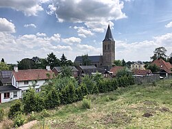
 View on Zeddam | |
| Coordinates: 51°54′11″N 6°15′25″E / 51.90311°N 6.25694°E | |
| Country | Netherlands |
| Province | Gelderland |
| Municipality | Montferland |
| Area | |
• Total | 3.64 km2 (1.41 sq mi) |
| Elevation | 18 m (59 ft) |
| Population (2021)[1] | |
• Total | 2,645 |
| • Density | 730/km2 (1,900/sq mi) |
| Time zone | UTC+1 (CET) |
| • Summer (DST) | UTC+2 (CEST) |
| Postal code | 7038[1] |
| Dialing code | 0314 |
Zeddam is a village in the Dutch province of Gelderland. It is located in the municipality of Montferland, about 7 km south of Doetinchem.
Zeddam was a separate municipality until 1821, when it was merged with Bergh.[3]
History
[edit]Zeddam was first mentioned between 1139 and 1148 as Sydehem. The etymology is unclear.[4] Zeddam is located on the flank of the Paasberg along the road from 's-Heerenberg to Doetinchem. It used to belong to the Lord of Bergh. The St. Oswaldus Church has a tower from around 1500 with a 14th century base. The church dates from 1891. Castle Montferland was a castle from the 9th century. The castle Uplade which was destroyed in 1066 may reference the same castle. It was demolished in 1527. In 1699, it was replaced by an estate which nowadays serves as a restaurant.[5] In 1840, it was home to 458 people.[6]
The Grafelijke Korenmolen is a tower mill that was first mentioned in 1451. In 1974, a horse mill was constructed next to mill in case there is no wind.[7]
Gallery
[edit]-
Zeddam, church: de Sint Oswaldkerk
-
House in Zeddam
-
Villa in Zeddam
-
Three mile poles
References
[edit]- ^ a b c "Kerncijfers wijken en buurten 2021". Central Bureau of Statistics. Retrieved 23 March 2022.
two entries
- ^ "Postcodetool for 7038AA". Actueel Hoogtebestand Nederland (in Dutch). Het Waterschapshuis. Retrieved 23 March 2022.
- ^ Ad van der Meer and Onno Boonstra, Repertorium van Nederlandse gemeenten, KNAW, 2011.
- ^ "Zeddam - (geografische naam)". Etymologiebank (in Dutch). Retrieved 23 March 2022.
- ^ Ronald Stenvert & Sabine Broekhoven (2000). "Zeddam" (in Dutch). Zwolle: Waanders. p. 347. ISBN 90 400 9406 3. Retrieved 23 March 2022.
- ^ "Zeddam". Plaatsengids (in Dutch). Retrieved 23 March 2022.
- ^ "Torenmolen Zeddam". Huis Bergh (in Dutch). Retrieved 23 March 2022.
 KSF
KSF


