Zemendorf-Stöttera
 From Wikipedia - Reading time: 6 min
Zemendorf-Stöttera | |
|---|---|
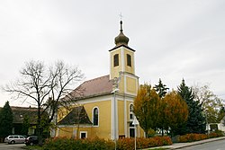
 Catholic church in Zemendorf | |
| Coordinates: 47°46′N 16°27′E / 47.767°N 16.450°E | |
| Country | Austria |
| State | Burgenland |
| District | Mattersburg |
| Government | |
| • Mayor | Josef Haider |
| Area | |
• Total | 12.83 km2 (4.95 sq mi) |
| Elevation | 198 m (650 ft) |
| Population (2018-01-01)[2] | |
• Total | 1,268 |
| • Density | 99/km2 (260/sq mi) |
| Time zone | UTC+1 (CET) |
| • Summer (DST) | UTC+2 (CEST) |
| Postal code | 7023 |
| Website | www.zemendorf-stoettera.at |
Zemendorf-Stöttera (Hungarian: Zemenye-Selegd; Croatian: Cemendrof-Štetr (Štedra, Stodra)) is a town in the district of Mattersburg in the Austrian state of Burgenland.
Geography
[edit]It consists of two parts, Zemendorf and Stöttera, both of which lie on the River Wulka downstream from Pöttelsdorf and upstream from Antau.
History
[edit]Until 1926, Stöttera was called Stöttern.
Population
[edit]| Year | Pop. | ±% |
|---|---|---|
| 1869 | 1,562 | — |
| 1880 | 1,674 | +7.2% |
| 1890 | 1,800 | +7.5% |
| 1900 | 1,745 | −3.1% |
| 1910 | 1,654 | −5.2% |
| 1923 | 1,562 | −5.6% |
| 1934 | 1,541 | −1.3% |
| 1939 | 1,489 | −3.4% |
| 1951 | 1,402 | −5.8% |
| 1961 | 1,315 | −6.2% |
| 1971 | 1,321 | +0.5% |
| 1981 | 1,282 | −3.0% |
| 1991 | 1,223 | −4.6% |
| 2001 | 1,272 | +4.0% |
| 2011 | 1,297 | +2.0% |
References
[edit]- ^ "Dauersiedlungsraum der Gemeinden Politischen Bezirke und Bundesländer - Gebietsstand 1.1.2018". Statistics Austria. Retrieved 10 March 2019.
- ^ "Einwohnerzahl 1.1.2018 nach Gemeinden mit Status, Gebietsstand 1.1.2018". Statistics Austria. Retrieved 9 March 2019.
Licensed under CC BY-SA 3.0 | Source: https://en.wikipedia.org/wiki/Zemendorf-Stöttera4 views | Status: cached on November 24 2024 04:06:22↧ Download as ZWI file
 KSF
KSF
