Ascension (eiland)
 From Wikipedia (Af) - Reading time: 2 min
| |||||
| Volkslied: God Save the Queen | |||||
| Hoofstad | Georgetown | ||||
| Grootste stad | Georgetown | ||||
| Amptelike tale | Engels | ||||
| Regering | Parlementêre demokrasie binne ’n grondwetlike monargie Elizabeth II Mark Capes Marc Holland | ||||
| Onafhanklikheid Vorming
• Eerste vestiging • Afhanklikheid van Sint Helena • Huidige grondwet |
Britse oorsese gebied 1815 12 September 1922 1 September 2009 | ||||
| Oppervlakte - Totaal - Water (%) |
88 km2 (219de) 34 myl2 0 | ||||
| Bevolking - 2008-skatting - Digtheid |
880 (-) 10 / km2 25,9 / myl2 | ||||
| Geldeenheid | Sint Heleense pond (SHP)
| ||||
| Tydsone - Somertyd |
GMT (UTC±0) nie toegepas nie (UTC±0) | ||||
| Internet-TLD | .ac | ||||
| Skakelkode | +247 | ||||


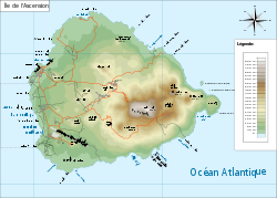
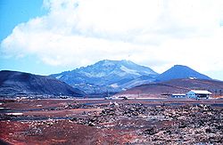
Ascension (Engels: Ascension Island) is 'n eiland in die suidelike Atlantiese Oseaan met 'n bevolking van 880 en 'n oppervlakte van 88 km². Ascension vorm saam met Sint Helena en Tristan da Cunha die Britse oorsese gebied Sint Helena, Ascension en Tristan da Cunha. Die hoofstad en grootste stad is Georgetown.
Bronne
[wysig | wysig bron]- (en) "Ascension". Encyclopædia Britannica. Besoek op 23 Augustus 2020.
- Green, Lawrence G.: South African beachcomber. Memories of the people of the shore and the stories they told; sand and dunes and treasure, seabirds and creatures of the sea; and personal impressions of certain islands in African waters. Kaapstad: Howard B. Timmins, 1958.
Eksterne skakels
[wysig | wysig bron] Wikimedia Commons het meer media in die kategorie Ascension (eiland).
- (en) Toerisme-inligting oor Ascension op Wikivoyage
- (en) Amptelike webwerf
Licensed under CC BY-SA 3.0 | Source: https://af.wikipedia.org/wiki/Ascension_(eiland)48 views | Status: cached on August 13 2025 20:13:32↧ Download this article as ZWI file
 KSF
KSF
