Omar (Sulu)
 From Wikipedia (De) - Reading time: 1 min
Koordinaten: 6° 1′ N, 121° 23′ O

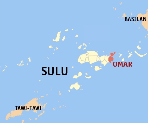
Omar ist eine Gemeinde auf den Philippinen und gehört zur Provinz Sulu. Sie liegt am Ostende der Hauptinsel Jolo und hat etwa 28.000 Einwohner (Stand 2020).[1]
Barangays
[Bearbeiten | Quelltext bearbeiten]Omar ist politisch in 8 Barangays unterteilt.[2]
|
|
Quellen
[Bearbeiten | Quelltext bearbeiten]- ↑ Municipality of Omar bei der Philippine Statistics Authority (englisch)
- ↑ Omar – Province of Sulu bei PhilAtlas (englisch)
Weblinks
[Bearbeiten | Quelltext bearbeiten]- Official Homepage des Municipal Government of Omar, Sulu (englisch)
Licensed under CC BY-SA 3.0 | Source: https://de.wikipedia.org/wiki/Omar_(Sulu)39 views | Status: cached on August 15 2025 21:46:25↧ Download this article as ZWI file
 KSF
KSF