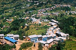
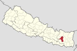
Distrito de Khotang
 From Wikipedia (Es) - Reading time: 2 min
| Distrito de Khotang | ||
|---|---|---|
| Distrito | ||
 | ||
 | ||
| Coordenadas | 27°12′00″N 86°47′00″E / 27.2, 86.783333333333 | |
| Capital | Diktel | |
| Idioma oficial | nepalí | |
| Entidad | Distrito | |
| • País |
| |
| • Zona administrativa | Sagarmatha | |
| Superficie | ||
| • Total | 1.591 km² | |
| Población (2011[1]) | ||
| • Total | 206,312 hab. | |
| • Densidad | 145,4 hab./km² | |
| Sitio web oficial | ||
El distrito de Khotang es uno de los seis distritos que conforman la Zona de Sagarmatha, en Nepal.
Comités de desarrollo rural
[editar]En el distrito se encuentran los siguientes comités de desarrollo rural.
- Ainselu Kharka
- Arkhale
- Badahare
- Badka Dipali
- Bahunidanda
- Bakachol
- Baksila
- Bamrang
- Barahapokhari
- Baspani
- Batase
- Bijaya Kharka
- Buipa
- Chhitapokhari
- Chhorambu
- Chipring
- Chisapani
- Chyandada
- Chyasmitar
- Damarkhu Shivalaya
- Dandagaun
- Devisthan
- Dharapani
- Dhitung
- Dikuwa
- Diplung
- Dipsung
- Dorpachiuridada
- Dumekoldada
- Dumre Dharapani
- Durchhim
- Faktang
- Ghitung
- Hauchour
- Indrayani Pokhari
- Jalapa
- Jyamire
- Kahalle
- Kaule
- Kharmi
- Kharpa
- Khartamchha
- Khidima
- Khotang Bazar
- Kuvinde
- Lafyang
- Lamidanda
- Lichki Ramche
- Linkuwa Pokhari
- Magpa
- Mahadevasthan
- Mangaltar
- Mattim Birta
- Mauwabote
- Nerpa
- Nirmalidada
- Nunthala
- Patheka
- Pauwasera
- Phedi
- R. Maheswori
- Rajapani
- Rakha Bangdel
- Rakha Dipsung
- Ratancha Majhagau
- Ribdung Jaleswori
- Ribdung Maheswori
- Salle
- Santeswor Chhitapokhari
- Sapteswor
- Saunechaur
- Sawakatahare
- Simpani
- Sungdel
- Suntale
- Tempa
- Woplukha
- Wopung
- Yamkhya
Referencias
[editar]Enlaces externos
[editar]- Districts of Nepal (en inglés).
- Khotang District (en inglés). (enlace roto disponible en Internet Archive; véase el historial, la primera versión y la última).
Licensed under CC BY-SA 3.0 | Source: https://es.wikipedia.org/wiki/Distrito_de_Khotang14 views | Status: cached on July 17 2025 14:54:29↧ Download this article as ZWI file
 KSF
KSF