Herndon (Pennsylvanie)
 From Wikipedia (Fr) - Reading time: 2 min
| Herndon | ||||
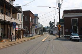
 La rue principale de Herndon. | ||||
| Administration | ||||
|---|---|---|---|---|
| Pays | ||||
| État | ||||
| Comté | Northumberland | |||
| Type de localité | Borough | |||
| Code ZIP | 17830 | |||
| Code FIPS | 42-34080 | |||
| GNIS | 1176878 | |||
| Indicatif(s) téléphonique(s) local (locaux) | 570 - 272 | |||
| Démographie | ||||
| Population | 324 hab. (2010) | |||
| Densité | 67 hab./km2 | |||
| Géographie | ||||
| Coordonnées | 40° 42′ 15″ nord, 76° 50′ 36″ ouest | |||
| Altitude | 138 m |
|||
| Superficie | 485 ha = 4,85 km2 | |||
| · dont terre | 2,22 km2 (45,77 %) | |||
| · dont eau | 2,63 km2 (54,23 %) | |||
| Divers | ||||
| Fondation | 1827 | |||
| Municipalité depuis | [1] | |||
| Localisation | ||||
 Carte du comté de Northumberland. | ||||
| Géolocalisation sur la carte : États-Unis
Géolocalisation sur la carte : États-Unis
Géolocalisation sur la carte : Pennsylvanie
| ||||
| modifier |
||||
Herndon est un borough situé au sud-ouest du comté de Northumberland, en Pennsylvanie, aux États-Unis[1],[2]. En 2010, il comptait une population de 324 habitants, estimée au à 392 habitants[3]. Le borough est incorporé le [1].
Démographie
[modifier | modifier le code]Lors du recensement de 2010, le borough comptait une population de 324 habitants. Elle est estimée, en 2020, à 392 habitants.
| Historique des recensements | |||
| Ann. | Pop. | %± | |
|---|---|---|---|
| 1880 | 306 | — | |
| 1910 | 620 | — | |
| 1920 | 656 | ▲ +5,81 % | |
| 1930 | 699 | ▲ +6,55 % | |
| 1940 | 687 | ▼ −1,72 % | |
| 1950 | 677 | ▼ −1,46 % | |
| 1960 | 622 | ▼ −8,12 % | |
| 1970 | 507 | ▼ −18,49 % | |
| 1980 | 483 | ▼ −4,73 % | |
| 1990 | 422 | ▼ −12,63 % | |
| 2000 | 383 | ▼ −9,24 % | |
| 2010 | 324 | ▼ −15,4 % | |
| Est. 2020 | 392 | [3] | |
| le site pennsylvania.hometownlocator.com | |||
Références
[modifier | modifier le code]- (en) « Herndon, Northumberland, Pennsylvania (IL) detailed profile » [« Données sur Herndon, comté de Northumberland, Pennsylvanie »], sur city-data.com (consulté le ).
- ↑ (en) « Herndon (Pennsylvanie) », Geographic Names Information System
- (en) « Herndon, PA Profile: Facts & Data », sur le site pennsylvania.hometownlocator.com (consulté le ).
Voir aussi
[modifier | modifier le code]Articles connexes
[modifier | modifier le code]Liens externes
[modifier | modifier le code]- Ressource relative à la géographie :
Source de la traduction
[modifier | modifier le code]- (en) Cet article est partiellement ou en totalité issu de l’article de Wikipédia en anglais intitulé « Herndon, Pennsylvania » (voir la liste des auteurs).
Licensed under CC BY-SA 3.0 | Source: https://fr.wikipedia.org/wiki/Herndon_(Pennsylvanie)17 views | Status: cached on April 08 2025 09:32:56↧ Download this article as ZWI file
 KSF
KSF


