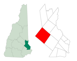
Strafford (New Hampshire)
 From Wikipedia (Fr) - Reading time: 2 min
Strafford
| Pays | |
|---|---|
| État | |
| Comté | |
| Superficie |
133,13 km2 |
| Altitude |
181 m |
| Coordonnées |
| Population |
4 230 hab. () |
|---|---|
| Densité |
31,8 hab./km2 () |
| Statut |
|---|
| Fondation |
|---|
| Code postal |
03884 |
|---|---|
| Code FIPS |
33-73860 |
| GNIS | |
| Indicatif téléphonique |
603 |
| Site web |
(en) strafford.nh.gov |
Strafford est une municipalité américaine située dans le comté de Strafford au New Hampshire. Selon le recensement de 2010, sa population est de 3 991 habitants[1].
Géographie
[modifier | modifier le code]La municipalité s'étend sur 51,38 milles carrés (133,07 km2), dont 2,22 milles carrés (5,75 km2) d'étendues d'eau[1].

|
Barnstead | Farmington | 
| |
| Pittsfield | N | Rochester | ||
| O Strafford E | ||||
| S | ||||
| Northwood | Barrington |
Histoire
[modifier | modifier le code]Strafford devient une municipalité indépendante de Barrington en 1820. Elle emprunte son nom au comté dans lequel elle se trouve, nommé en l'honneur de la famille Wentworth, comtes de Strafford[2].
Démographie
[modifier | modifier le code]| Historique des recensements | |||
| Année | Pop. | %± | |
|---|---|---|---|
| 1820 | 2 144 | — | |
| 1830 | 2 200 | ▲ +2,61 % | |
| 1840 | 2 021 | ▼ −8,14 % | |
| 1850 | 1 920 | ▼ −5 % | |
| 1860 | 2 047 | ▲ +6,61 % | |
| 1870 | 1 669 | ▼ −18,47 % | |
| 1880 | 1 531 | ▼ −8,27 % | |
| 1890 | 1 304 | ▼ −14,83 % | |
| 1900 | 1 040 | ▼ −20,25 % | |
| 1910 | 786 | ▼ −24,42 % | |
| 1920 | 764 | ▼ −2,8 % | |
| 1930 | 617 | ▼ −19,24 % | |
| 1940 | 714 | ▲ +15,72 % | |
| 1950 | 770 | ▲ +7,84 % | |
| 1960 | 722 | ▼ −6,23 % | |
| 1970 | 965 | ▲ +33,66 % | |
| 1980 | 1 663 | ▲ +72,33 % | |
| 1990 | 2 965 | ▲ +78,29 % | |
| 2000 | 3 626 | ▲ +22,29 % | |
| 2010 | 3 991 | ▲ +10,07 % | |
| Est. 2015 | 4 074 | ||
Notes et références
[modifier | modifier le code]- (en) Bureau du recensement des États-Unis, « Population, Housing Units, Area, and Density: 2010 - State -- Place and (in selected states) County Subdivision 2010 Census Summary File 1 », sur factfinder.census.gov (consulté le ).
- ↑ (en) Economic & Labor Market Information Bureau, « Strafford, NH », Community Profiles, sur nhes.nh.gov, (consulté le ).
Licensed under CC BY-SA 3.0 | Source: https://fr.wikipedia.org/wiki/Strafford_(New_Hampshire)38 views | Status: cached on July 02 2025 21:45:04↧ Download this article as ZWI file
 KSF
KSF


